Home > Stocktrek Images > Military
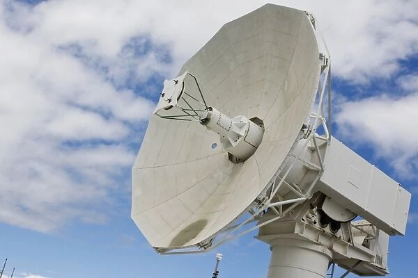
A radar dish aboard Mobile At-Sea Sensor barge
![]()

Wall Art and Photo Gifts from Stocktrek
A radar dish aboard Mobile At-Sea Sensor barge
Pearl Harbor, August 24, 2011 - A radar dish aboard Mobile At-Sea Sensor (MATSS) barge (IX-524) undergoes final testing before upcoming flight test mission FTM-16. MATSS provides advanced remote telecommunications capability that extends the reach of the 42, 000 square-mile Pacific Missile Range, the worlds largest instrumented multi-environmental range capable of supported surface, subsurface, air, and space operations simultaneously
Stocktrek Images specializes in Astronomy, Dinosaurs, Medical, Military Forces, Ocean Life, & Sci-Fi
Media ID 13016759
© Stocktrek Images
Antenna Communication Concave Connection Defense Equipment Facility Hawaii Pearl Harbor Radar Radio Telescope Remote Research Satellite Satellite Dish Strategic Technology Telecommunications Transmitter
EDITORS COMMENTS
This print showcases a radar dish aboard the Mobile At-Sea Sensor (MATSS) barge, taken at Pearl Harbor on August 24,2011. The image captures the final testing phase of this cutting-edge radar system before its upcoming flight test mission FTM-16. MATSS plays a crucial role in extending the reach of the Pacific Missile Range, which spans an impressive 42,000 square miles and is renowned as the world's largest instrumented multi-environmental range. With no people present in the frame, this photograph focuses solely on this remarkable piece of military technology. Its concave shape and intricate design highlight its significance in telecommunications and defense operations. As part of a strategic satellite facility based in Hawaii, this radar dish enables advanced remote communications capabilities across vast distances. The image exudes a sense of power and innovation as it portrays not only the physical equipment but also represents research advancements in remote science and technology. This radio telescope-like antenna serves as a transmitter for critical data connections that support surface, subsurface, air, and space operations simultaneously. Set against a backdrop of clear blue skies with wisps of clouds overhead, this color photograph emphasizes both the functional aspects and aesthetic appeal of such sophisticated military infrastructure. It stands as a testament to human ingenuity while reminding us of our ongoing pursuit to push boundaries in defense systems development without mentioning any commercial use or specific company involved – all captured beautifully by Stocktrek Images.
MADE IN THE UK
Safe Shipping with 30 Day Money Back Guarantee
FREE PERSONALISATION*
We are proud to offer a range of customisation features including Personalised Captions, Color Filters and Picture Zoom Tools
SECURE PAYMENTS
We happily accept a wide range of payment options so you can pay for the things you need in the way that is most convenient for you
* Options may vary by product and licensing agreement. Zoomed Pictures can be adjusted in the Basket.

