Home > Europe > United Kingdom > Scotland > Aberdeenshire > Blackburn
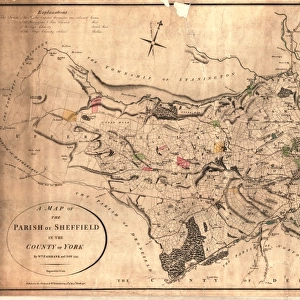
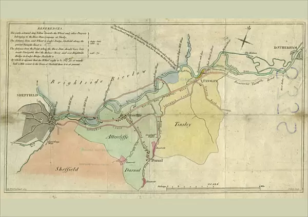
Poster Print : A plan of the intended canal from Sheffield to Tinsley by W. and J. Fairbank, 1815


![]()
Poster Prints from Sheffield City Archives
A plan of the intended canal from Sheffield to Tinsley by W. and J. Fairbank, 1815
Includes Greenland Engine.Original at Local Studies S33S
Sheffield City Archives and Local Studies Library has an unrivalled collection of images of Sheffield, England
Media ID 14048895
© Sheffield City Council
Attercliffe Brightside Brook Canals Carbrook Darnall Forge Hill Maps Mill Porter River Rivers Road Sheaf Street Tinsley Walk Wicker Acres Bawtry Blackburn Dyke Holmes Royds Weir Weirs Worksop
A1 (84.1 x 59.4cm) Poster Print
Introducing the Media Storehouse Poster Prints, featuring an intriguing historical plan of Sheffield's intended canal from Sheffield to Tinsley. Dating back to 1815, this captivating map is an original creation of W. and J. Fairbank, now preserved at Sheffield City Archives (Local Studies S33S). Immerse yourself in the rich history of Sheffield's industrial past with this detailed and beautifully crafted poster print. The map showcases the proposed canal route, complete with the iconic Greenland Engine, a testament to the engineering prowess of the time. Bring the history of Sheffield's industrial revolution into your home or office with this stunning and authentic poster print. A perfect addition to any history enthusiast's collection or a unique gift for those with an appreciation for the past. Experience the beauty of history in high definition with Media Storehouse's premium quality poster prints. Each print is carefully produced using top-tier materials and printing techniques, ensuring a vibrant and long-lasting display. Order yours today and step back in time with this captivating piece of Sheffield's heritage.
A1 Poster (84.1 x 59.4cm, 33.1" x 23.4" inches) printed on 170gsm Satin Poster Paper. Securely packaged, rolled and inserted into a strong mailing tube and shipped tracked. Poster Prints are of comparable archival quality to our Photographic prints, they are simply printed on thinner Poster Paper. Whilst we only use Photographic Prints in our frames, you can frame Poster Prints if they are carefully supported to prevent sagging over time.
Poster prints are budget friendly enlarged prints in standard poster paper sizes (A0, A1, A2, A3 etc). Whilst poster paper is sometimes thinner and less durable than our other paper types, they are still ok for framing and should last many years. Our Archival Quality Photo Prints and Fine Art Paper Prints are printed on higher quality paper and the choice of which largely depends on your budget.
Estimated Image Size (if not cropped) is 84.1cm x 49.3cm (33.1" x 19.4")
Estimated Product Size is 84.1cm x 59.4cm (33.1" x 23.4")
These are individually made so all sizes are approximate
Artwork printed orientated as per the preview above, with landscape (horizontal) orientation to match the source image.
FEATURES IN THESE COLLECTIONS
> Arts
> Landscape paintings
> Waterfall and river artworks
> River artworks
> Arts
> Portraits
> Pop art gallery
> Street art portraits
> Europe
> United Kingdom
> Scotland
> Aberdeenshire
> Blackburn
> Europe
> United Kingdom
> Scotland
> West Lothian
> Blackburn
> Maps and Charts
> Related Images
> North America
> Greenland
> Maps
> North America
> Greenland
> Related Images
> Sheffield City Archives
> Maps and Plans
> Maps of Sheffield
> Sheffield City Archives
> Maps and Plans
Discovering Sheffield's Historic Waterways - A Glimpse into the Past
EDITORS COMMENTS
. This print showcases a remarkable piece of history - "A plan of the intended canal from Sheffield to Tinsley" meticulously crafted by W. and J. Fairbank in 1815. Preserved at the Local Studies S33S section of Sheffield City Archives, this extraordinary map offers an intriguing insight into the city's rich industrial heritage. The image depicts a network of canals stretching from Sheffield to Tinsley, encompassing notable landmarks such as Greenland Engine, rivers Sheaf and Porter, Royds Mill, and Brightside Weir among others. The intricate details on this map invite us to embark on a virtual journey through time. As we explore further, we encounter familiar names like Bawtry Road, Blackburn Acres, Darnall Hill Dyke, Carbrook Forge Pond – all reminders of how these areas have evolved over centuries. This snapshot transports us back to an era when waterways were vital for transportation and trade in Sheffield. While admiring this historical gem captured within the frame, let's take a moment to appreciate the efforts made by our ancestors who shaped these canals that once bustled with activity. This print serves as a reminder of our city's industrious past and encourages us to cherish its legacy
MADE IN THE UK
Safe Shipping with 30 Day Money Back Guarantee
FREE PERSONALISATION*
We are proud to offer a range of customisation features including Personalised Captions, Color Filters and Picture Zoom Tools
SECURE PAYMENTS
We happily accept a wide range of payment options so you can pay for the things you need in the way that is most convenient for you
* Options may vary by product and licensing agreement. Zoomed Pictures can be adjusted in the Basket.