Home > Arts > Artists > B > Emanuel Bowen
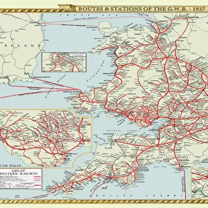
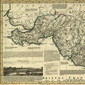
Map of North Wales, c. 1777

![]()
Wall Art and Photo Gifts from Sheffield City Archives
Map of North Wales, c. 1777
From The Large English Atlas: or, a new set of map of all the counties of England and Wales drawn from the several surveys which have been hitherto been published. With three general maps of England, Scotland and Ireland, from the latest and best authorities, by Emanuel Bowen, Thomas Kitchin and others. London, printed and sold by T. Bowles, [c.1777]
Original at Sheffield Libraries: 912 STF
Sheffield City Archives and Local Studies Library has an unrivalled collection of images of Sheffield, England
Media ID 25501443
© Sheffield City Council - All Rights Reserved
Antique Map Bowens Map County Map Emanuel Bowen Old Map Thomas Kitchin Aberdovey Abergele Anglesey Bala Bangor Barmouth Betws Y Coed Blaenau Ffestiniog Caernarfon Caernarfonshire Caernarvonshire Carnarvonshire Colwyn Bay Conwy Corwen Denbigh Denbighshire Dolgellau Ffestiniog Harlech Llandudno Llangollen Llanidloes Llanrwst Machynlleth Merionethshire Montgomery Montgomeryshire Newtown Porthmadog Pwllheli Rhyl Ruthin Snowdon Snowdonia Tywyn Welshpool Wrexham
FEATURES IN THESE COLLECTIONS
> Arts
> Artists
> B
> Emanuel Bowen
> Arts
> Artists
> K
> Thomas Kitchin
> Europe
> Republic of Ireland
> Maps
> Europe
> United Kingdom
> England
> London
> Related Images
> Europe
> United Kingdom
> England
> Maps
> Europe
> United Kingdom
> England
> Sheffield
> Europe
> United Kingdom
> Northern Ireland
> County Down
> Bangor
> Europe
> United Kingdom
> Scotland
> Maps
> Europe
> United Kingdom
> Wales
> Anglesey
> Related Images
> Europe
> United Kingdom
> Wales
> Bangor
> Sheffield City Archives
> Maps and Plans
> Bowen's County Maps, c. 1777
> Sheffield City Archives
> Maps and Plans
> Maps of Wales
EDITORS COMMENTS
This antique map print showcases the stunning "Map of North Wales" from around 1777. Originally featured in "The Large English Atlas: or, a new set of maps of all the counties of England and Wales" this historical piece was meticulously drawn by renowned cartographers Emanuel Bowen, Thomas Kitchin, and others. The map provides a fascinating glimpse into the geographical landscape of North Wales during that era. It highlights prominent locations such as Anglesey, Caernarfonshire (also known as Caernarvonshire or Carnarvonshire), Snowdonia with its majestic peak Snowdon, Bardsey Island, Bangor, Betws-y-Coed, Caernarfon, Conwy, Porthmadog, Pwllheli, Llandudno and many more. With intricate details and precise markings denoting towns like Denbighshire's Rhyl and Abergele to Denbigh's Mochdre; from Llangollen to Llanrwst; Wrexham to Colwyn Bay; Ruthin to Merionethshire's Dolgellau; Aberdovey to Bala; Barmouth to Blaenau Ffestiniog; Corwen to Ffestiniog; Harlech to Tywyn - it offers an invaluable historical record. Preserved at Sheffield Libraries under reference number 912 STF within their archives collection is where this remarkable original can be found. Its depiction serves as a testament not only to
MADE IN THE UK
Safe Shipping with 30 Day Money Back Guarantee
FREE PERSONALISATION*
We are proud to offer a range of customisation features including Personalised Captions, Color Filters and Picture Zoom Tools
SECURE PAYMENTS
We happily accept a wide range of payment options so you can pay for the things you need in the way that is most convenient for you
* Options may vary by product and licensing agreement. Zoomed Pictures can be adjusted in the Basket.