Home > Arts > Artists > B > Emanuel Bowen
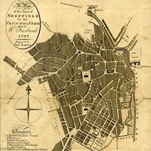
County Map of Westmoreland and Cumberland, c. 1777

![]()
Wall Art and Photo Gifts from Sheffield City Archives
County Map of Westmoreland and Cumberland, c. 1777
From The Large English Atlas: or, a new set of map of all the counties of England and Wales drawn from the several surveys which have been hitherto been published. With three general maps of England, Scotland and Ireland, from the latest and best authorities, by Emanuel Bowen, Thomas Kitchin and others. London, printed and sold by T. Bowles, [c.1777]
Original at Sheffield Libraries: 912 STF
Sheffield City Archives and Local Studies Library has an unrivalled collection of images of Sheffield, England
Media ID 25501515
© Sheffield City Council - All Rights Reserved
Antique Map Bowens Map County Map Emanuel Bowen Holme Old Map Thomas Kitchin Allerdale Ambleside Appleby Bampton Barton Brampton Brough Cockermouth Cumberland Egremont Eskdale Grasmere Kendal Kentmere Keswick Kirkby Lonsdale Kirkby Stephen Lake District Maryport Millom Orton Patterdale Penrith Shap Tebay Westmoreland Westmorland Whitehaven Wigton Windermere Workington
FEATURES IN THESE COLLECTIONS
> Arts
> Artists
> B
> Emanuel Bowen
> Arts
> Artists
> K
> Thomas Kitchin
> Europe
> Republic of Ireland
> Lakes
> Related Images
> Europe
> Republic of Ireland
> Maps
> Europe
> United Kingdom
> England
> Cumberland
> Europe
> United Kingdom
> England
> Lakes
> Europe
> United Kingdom
> England
> London
> Related Images
> Europe
> United Kingdom
> England
> Maps
> Europe
> United Kingdom
> England
> Sheffield
> Europe
> United Kingdom
> England
> Westmorland
> Sheffield City Archives
> Maps and Plans
> Bowen's County Maps, c. 1777
EDITORS COMMENTS
This print showcases a County Map of Westmoreland and Cumberland, dating back to approximately 1777. The map is an exquisite piece from "The Large English Atlas: or, a new set of maps of all the counties of England and Wales" meticulously crafted by renowned cartographers Emanuel Bowen, Thomas Kitchin, and others. With its intricate details and historical significance, this antique map offers a glimpse into the past. It highlights various towns and landmarks within Westmoreland and Cumberland such as Appleby, Brough, Kirkby Stephen, Orton, Tebay, Askham, Bampton, Barton, Patterdale, Shap, Yanwith Ambleside, Burton in Kendal, and many more. The map also encompasses notable regions like the Lake District with its picturesque landscapes including Grasmere, Kentmere, Windermere, Kirkby Lonsdale, Cumberland's Allerdale, Eskdale, and Leath. Additionally, it features significant towns like Carlisle, Wigton, Brampton, Cleator Moor, Cockermouth, Egremont, Holme Cultram, Keswick, Maryport , Millom, Penrith , Whitehaven , and Workington. Preserved at Sheffield Libraries (912 STF), this remarkable artifact provides valuable insights into the geography and history of these counties during that era. Its inclusion in the archives signifies its importance as a cultural heritage item. As we explore this enchanting image capturing centuries-old cartographic expertise by Bowen
MADE IN THE UK
Safe Shipping with 30 Day Money Back Guarantee
FREE PERSONALISATION*
We are proud to offer a range of customisation features including Personalised Captions, Color Filters and Picture Zoom Tools
SECURE PAYMENTS
We happily accept a wide range of payment options so you can pay for the things you need in the way that is most convenient for you
* Options may vary by product and licensing agreement. Zoomed Pictures can be adjusted in the Basket.