Home > Arts > Artists > B > Emanuel Bowen
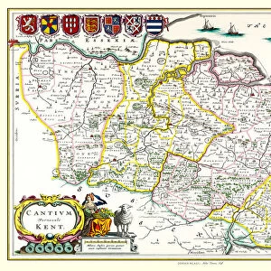
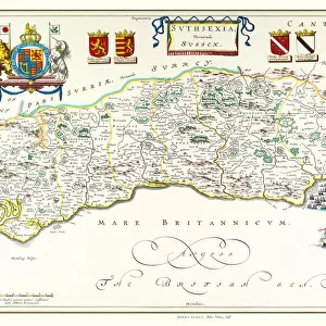
County Map of Sussex, c. 1777

![]()
Wall Art and Photo Gifts from Sheffield City Archives
County Map of Sussex, c. 1777
From The Large English Atlas: or, a new set of map of all the counties of England and Wales drawn from the several surveys which have been hitherto been published. With three general maps of England, Scotland and Ireland, from the latest and best authorities, by Emanuel Bowen, Thomas Kitchin and others. London, printed and sold by T. Bowles, [c.1777]
Original at Sheffield Libraries: 912 STF
Sheffield City Archives and Local Studies Library has an unrivalled collection of images of Sheffield, England
Media ID 25501505
© Sheffield City Council - All Rights Reserved
Antique Map Bowens Map County Map Emanuel Bowen Old Map Thomas Kitchin Bexhill On Sea Bognor Regis Brighton Burgess Hill Chichester Crawly Crowborough East Grinstead Eastbourne Hailsham Haywards Heath Horsham Hove Hurstpierpoint Lewes Littlehampton Newhaven Peacehaven Seaford Selsey Shoreham By Sea Southwater Southwick Uckfield Worthing
FEATURES IN THESE COLLECTIONS
> Arts
> Artists
> B
> Emanuel Bowen
> Arts
> Artists
> K
> Thomas Kitchin
> Europe
> Republic of Ireland
> Maps
> Europe
> United Kingdom
> England
> Brighton & Hove
> Europe
> United Kingdom
> England
> Chichester
> Europe
> United Kingdom
> England
> London
> Related Images
> Europe
> United Kingdom
> England
> Maps
> Europe
> United Kingdom
> England
> Sheffield
> Europe
> United Kingdom
> England
> Sussex
> Battle
> Europe
> United Kingdom
> England
> Sussex
> Bexhill
> Sheffield City Archives
> Maps and Plans
> Bowen's County Maps, c. 1777
EDITORS COMMENTS
This antique map, titled "County Map of Sussex, c. 1777" is a fascinating piece from The Large English Atlas. Created by renowned cartographers Emanuel Bowen and Thomas Kitchin, this print offers a glimpse into the historical geography of Sussex during the late 18th century. The intricate details on this map showcase various towns and landmarks across Sussex, including Brighton, Hove, Eastbourne, Bexhill-on-Sea, Seaford, Crowborough, Hailsham, Portslade-by-Sea, Peacehaven, Lewes, Uckfield and many more. It provides an invaluable resource for historians and enthusiasts interested in exploring the county's past. With its delicate lines and elegant typography characteristic of maps from that era; this print is not only visually captivating but also holds immense historical significance. It allows us to trace the development of towns over time and understand how they were interconnected within the region. Preserved at Sheffield Libraries' archives (912 STF), this original map serves as a testament to the craftsmanship of Bowen and Kitchin. Its presence reminds us of their dedication to accurately representing England's counties through extensive surveys conducted at that time. Whether you are a history buff or simply appreciate vintage cartography; this County Map of Sussex transports you back in time to experience the landscapes that have shaped generations before us.
MADE IN THE UK
Safe Shipping with 30 Day Money Back Guarantee
FREE PERSONALISATION*
We are proud to offer a range of customisation features including Personalised Captions, Color Filters and Picture Zoom Tools
SECURE PAYMENTS
We happily accept a wide range of payment options so you can pay for the things you need in the way that is most convenient for you
* Options may vary by product and licensing agreement. Zoomed Pictures can be adjusted in the Basket.