Home > Europe > United Kingdom > England > Surrey > Ashford
County Map of Surrey, c. 1777

![]()
Wall Art and Photo Gifts from Sheffield City Archives
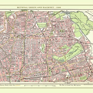
County Map of Surrey, c. 1777
From The Large English Atlas: or, a new set of map of all the counties of England and Wales drawn from the several surveys which have been hitherto been published. With three general maps of England, Scotland and Ireland, from the latest and best authorities, by Emanuel Bowen, Thomas Kitchin and others. London, printed and sold by T. Bowles, [c.1777]
Original at Sheffield Libraries: 912 STF
Sheffield City Archives and Local Studies Library has an unrivalled collection of images of Sheffield, England
Media ID 25501503
© Sheffield City Council - All Rights Reserved
Antique Map Bowens Map County Map Emanuel Bowen Old Map Surrey Thomas Kitchin Ashford Camberley Caterham Egham Epsom Esher Ewell Farnham Godalming Guildford Horley Leatherhead Redhill Reigate Staines Walton On Thames Weybridge Woking
FEATURES IN THESE COLLECTIONS
> Arts
> Artists
> B
> Emanuel Bowen
> Arts
> Artists
> K
> Thomas Kitchin
> Europe
> Republic of Ireland
> Maps
> Europe
> United Kingdom
> England
> London
> Related Images
> Europe
> United Kingdom
> England
> Maps
> Europe
> United Kingdom
> England
> Sheffield
> Europe
> United Kingdom
> England
> Surrey
> Ashford
> Europe
> United Kingdom
> England
> Surrey
> Camberley
> Europe
> United Kingdom
> England
> Surrey
> Caterham
> Europe
> United Kingdom
> England
> Surrey
> Egham
> Sheffield City Archives
> Maps and Plans
> Bowen's County Maps, c. 1777
EDITORS COMMENTS
This antique map, titled "County Map of Surrey, c. 1777" is a true treasure from the past. Crafted by renowned cartographers Emanuel Bowen and Thomas Kitchin, this print showcases their exceptional talent in capturing the intricate details of England's counties. The map takes us on a journey through time, offering a glimpse into Surrey's rich history. From bustling towns like Woking and Guildford to picturesque riverside settlements such as Walton-on-Thames and Ewell, every corner of this county is meticulously depicted. As we explore further, we encounter charming towns like Esher and Camberley nestled amidst lush greenery. The vibrant markets of Redhill and Leatherhead come alive on this print, while the elegant architecture of Epsom and Weybridge adds an air of sophistication. Venturing towards the outskirts, we stumble upon hidden gems like Ashford and Egham that boast their own unique charm. Staines stands proud with its historic significance as a crossing point over the River Thames. Meanwhile, Farnham exudes tranquility with its quaint streets lined with timber-framed houses. From Horley to Godalming, Reigate to Caterham - each town tells its own story within this remarkable piece of artistry. This map serves not only as a visual delight but also as an invaluable historical document for those seeking to understand Surrey's evolution over centuries. Preserved at Sheffield Libraries: 912 STF in all its glory, this vintage map allows us
MADE IN THE UK
Safe Shipping with 30 Day Money Back Guarantee
FREE PERSONALISATION*
We are proud to offer a range of customisation features including Personalised Captions, Color Filters and Picture Zoom Tools
SECURE PAYMENTS
We happily accept a wide range of payment options so you can pay for the things you need in the way that is most convenient for you
* Options may vary by product and licensing agreement. Zoomed Pictures can be adjusted in the Basket.