Home > Arts > Artists > B > Emanuel Bowen
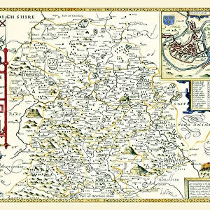
County Map of Shropshire, c. 1777

![]()
Wall Art and Photo Gifts from Sheffield City Archives
County Map of Shropshire, c. 1777
From The Large English Atlas: or, a new set of map of all the counties of England and Wales drawn from the several surveys which have been hitherto been published. With three general maps of England, Scotland and Ireland, from the latest and best authorities, by Emanuel Bowen, Thomas Kitchin and others. London, printed and sold by T. Bowles, [c.1777]
Original at Sheffield Libraries: 912 STF
Sheffield City Archives and Local Studies Library has an unrivalled collection of images of Sheffield, England
Media ID 25501495
© Sheffield City Council - All Rights Reserved
Antique Map Bowens Map County Map Emanuel Bowen Old Map Thomas Kitchin Bridgnorth Clun Ludlow Madeley Newport Oswestry Shropshire Telford Whitchurch
FEATURES IN THESE COLLECTIONS
> Arts
> Artists
> B
> Emanuel Bowen
> Arts
> Artists
> K
> Thomas Kitchin
> Europe
> Republic of Ireland
> Maps
> Europe
> United Kingdom
> England
> Castles
> Europe
> United Kingdom
> England
> London
> Related Images
> Europe
> United Kingdom
> England
> Maps
> Europe
> United Kingdom
> England
> Sheffield
> Europe
> United Kingdom
> England
> Shropshire
> Bridgnorth
> Europe
> United Kingdom
> England
> Shropshire
> Clun
> Europe
> United Kingdom
> England
> Shropshire
> Craven Arms
> Sheffield City Archives
> Maps and Plans
> Bowen's County Maps, c. 1777
EDITORS COMMENTS
This print showcases a County Map of Shropshire, dating back to approximately 1777. A true antique gem, it originates from "The Large English Atlas: or, a new set of maps of all the counties of England and Wales" meticulously crafted by renowned cartographers Emanuel Bowen, Thomas Kitchin, and others. The map was printed and sold in London by T. Bowles during that era. Displayed against a backdrop of history at Sheffield Libraries, this remarkable piece offers an intriguing glimpse into the past. With intricate details and delicate artistry, it unveils the enchanting landscapes and towns within Shropshire's borders. From Bridgnorth to Clun, Craven Arms to Ludlow, Madeley to Market Drayton - each place is carefully etched onto this vintage treasure. As we explore this ancient map further, our eyes are drawn to prominent locations such as Newport with its rich heritage and Oswestry with its historical significance. We also catch sight of Telford's emergence as an industrial hub alongside Wem's quaint charm and Whitchurch's timeless allure. Immerse yourself in the beauty of yesteryears through this extraordinary print that encapsulates not only Shropshire's geography but also the craftsmanship of eminent cartographers who dedicated their skills to documenting our world. Let your imagination wander through time as you marvel at every contour line on this historic masterpiece preserved for generations to come.
MADE IN THE UK
Safe Shipping with 30 Day Money Back Guarantee
FREE PERSONALISATION*
We are proud to offer a range of customisation features including Personalised Captions, Color Filters and Picture Zoom Tools
SECURE PAYMENTS
We happily accept a wide range of payment options so you can pay for the things you need in the way that is most convenient for you
* Options may vary by product and licensing agreement. Zoomed Pictures can be adjusted in the Basket.