Home > Arts > Artists > B > Emanuel Bowen
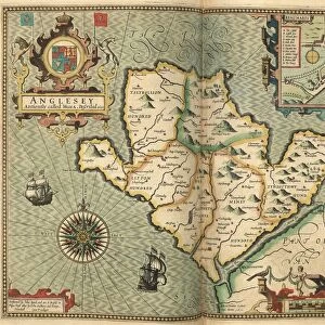
County Map of Radnorshire, Wales, c. 1777

![]()
Wall Art and Photo Gifts from Sheffield City Archives
County Map of Radnorshire, Wales, c. 1777
From The Large English Atlas: or, a new set of map of all the counties of England and Wales drawn from the several surveys which have been hitherto been published. With three general maps of England, Scotland and Ireland, from the latest and best authorities, by Emanuel Bowen, Thomas Kitchin and others. London, printed and sold by T. Bowles, [c.1777]
Original at Sheffield Libraries: 912 STF
Sheffield City Archives and Local Studies Library has an unrivalled collection of images of Sheffield, England
Media ID 25501481
© Sheffield City Council - All Rights Reserved
Antique Map Bowens Map County Map Emanuel Bowen Old Map Thomas Kitchin Knighton Llandrindod Wells Presteigne Radnorshire Rhayader
FEATURES IN THESE COLLECTIONS
> Arts
> Artists
> B
> Emanuel Bowen
> Arts
> Artists
> K
> Thomas Kitchin
> Europe
> Republic of Ireland
> Maps
> Europe
> United Kingdom
> England
> London
> Related Images
> Europe
> United Kingdom
> England
> Maps
> Europe
> United Kingdom
> England
> Sheffield
> Europe
> United Kingdom
> England
> Wells
> Europe
> United Kingdom
> Scotland
> Maps
> Europe
> United Kingdom
> Wales
> Maps
> Europe
> United Kingdom
> Wales
> Powys
> Knighton
> Sheffield City Archives
> Maps and Plans
> Bowen's County Maps, c. 1777
> Sheffield City Archives
> Maps and Plans
> Maps of Wales
EDITORS COMMENTS
This print showcases the "County Map of Radnorshire, Wales" dating back to approximately 1777. The map is a remarkable piece from "The Large English Atlas: or, a new set of maps of all the counties of England and Wales" meticulously crafted by renowned cartographers Emanuel Bowen, Thomas Kitchin, and others. With its intricate details and artistic flair, this antique map offers a glimpse into the historical landscape of Radnorshire during that era. Nestled in central Wales, Radnorshire's towns such as Knighton, Llandrindod Wells, Presteigne, Rhayader, Newbridge on Wye, and New Radnor are beautifully depicted with precision. As we explore this enchanting map further at Sheffield Libraries' archives (912 STF), it becomes evident that it was created using the best available surveys at the time. The craftsmanship is truly commendable; every contour line and waterway has been delicately etched onto paper. While admiring this stunning visual representation of Radnorshire's geography from centuries ago, one can't help but appreciate how far cartography has come since then. This print serves as a reminder of our rich history and provides an opportunity to reflect upon how landscapes have evolved over time
MADE IN THE UK
Safe Shipping with 30 Day Money Back Guarantee
FREE PERSONALISATION*
We are proud to offer a range of customisation features including Personalised Captions, Color Filters and Picture Zoom Tools
SECURE PAYMENTS
We happily accept a wide range of payment options so you can pay for the things you need in the way that is most convenient for you
* Options may vary by product and licensing agreement. Zoomed Pictures can be adjusted in the Basket.