Home > Arts > Artists > B > Emanuel Bowen
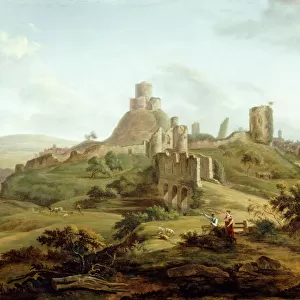
County Map of Cornwall, c. 1777

![]()
Wall Art and Photo Gifts from Sheffield City Archives
County Map of Cornwall, c. 1777
From The Large English Atlas: or, a new set of map of all the counties of England and Wales drawn from the several surveys which have been hitherto been published. With three general maps of England, Scotland and Ireland, from the latest and best authorities, by Emanuel Bowen, Thomas Kitchin and others. London, printed and sold by T. Bowles, [c.1777]
Original at Sheffield Libraries: 912 STF
Sheffield City Archives and Local Studies Library has an unrivalled collection of images of Sheffield, England
Media ID 25438312
© Sheffield City Council - All Rights Reserved
Antique Map Bowens Map County Map Emanuel Bowen Old Map Thomas Kitchin Bodmin Bude Falmouth Hayle Lands End Launceston Liskeard Looe Newquay Penzance Redruth Saltash St Austell St Ives Torpoint Truro Wadebridge
FEATURES IN THESE COLLECTIONS
> Arts
> Artists
> B
> Emanuel Bowen
> Arts
> Artists
> K
> Thomas Kitchin
> Europe
> Republic of Ireland
> Maps
> Europe
> United Kingdom
> England
> Cornwall
> Bodmin
> Europe
> United Kingdom
> England
> Cornwall
> Bude
> Europe
> United Kingdom
> England
> Cornwall
> Falmouth
> Europe
> United Kingdom
> England
> Cornwall
> Hayle
> Europe
> United Kingdom
> England
> Cornwall
> Launceston
> Europe
> United Kingdom
> England
> Cornwall
> Liskeard
> Europe
> United Kingdom
> England
> Cornwall
> Looe
> Sheffield City Archives
> Maps and Plans
> Bowen's County Maps, c. 1777
EDITORS COMMENTS
This antique map, titled "County Map of Cornwall, c. 1777" is a fascinating glimpse into the past. Created by renowned cartographers Emanuel Bowen and Thomas Kitchin, this print showcases the intricate details of Cornwall's geography during the late 18th century. The map highlights various towns and landmarks that were significant to Cornwall's history. From bustling ports like Falmouth and Penzance to inland settlements such as Truro and Bodmin, each location is carefully labeled with ornate typography. Cornwall's rugged coastline is beautifully depicted, with its jagged cliffs and picturesque bays captured in exquisite detail. The map also includes notable features like St Ives Bay, Land's End, and Looe Island - all contributing to the county's unique charm. As you explore this historical document further, you'll notice smaller villages nestled among rolling hillsides dotted with farms. Saltash Bridge elegantly spans across the River Tamar connecting Cornwall to Devonshire. This particular print originates from "The Large English Atlas: or, a new set of maps of all the counties of England and Wales". It serves as a testament to the skillful craftsmanship of Bowen, Kitchin, and their contemporaries who meticulously surveyed these lands. Preserved within Sheffield Libraries' archives for centuries now resides an invaluable piece of Cornish heritage. This map allows us to trace our roots back in time while appreciating how much has changed since then.
MADE IN THE UK
Safe Shipping with 30 Day Money Back Guarantee
FREE PERSONALISATION*
We are proud to offer a range of customisation features including Personalised Captions, Color Filters and Picture Zoom Tools
SECURE PAYMENTS
We happily accept a wide range of payment options so you can pay for the things you need in the way that is most convenient for you
* Options may vary by product and licensing agreement. Zoomed Pictures can be adjusted in the Basket.