Home > Europe > United Kingdom > England > Cambridgeshire > Chatteris
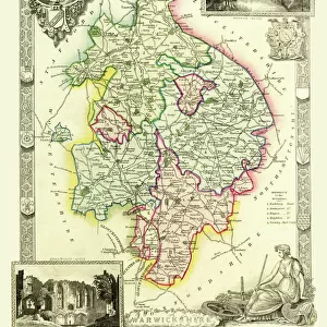
County Map of Cambridgeshire c. 1777

![]()
Wall Art and Photo Gifts from Sheffield City Archives
County Map of Cambridgeshire c. 1777
From The Large English Atlas: or, a new set of map of all the counties of England and Wales drawn from the several surveys which have been hitherto been published. With three general maps of England, Scotland and Ireland, from the latest and best authorities, by Emanuel Bowen, Thomas Kitchin and others. London, printed and sold by T. Bowles, [c.1777]
Original at Sheffield Libraries: 912 STF
Sheffield City Archives and Local Studies Library has an unrivalled collection of images of Sheffield, England
Media ID 25437332
© Sheffield City Council - All Rights Reserved
Antique Map Bowens Map County Map Emanuel Bowen Old Map Thomas Kitchin Cambridge Cambridgeshire Peterborough Whittlesey Wisbech
FEATURES IN THESE COLLECTIONS
> Arts
> Artists
> B
> Emanuel Bowen
> Arts
> Artists
> K
> Thomas Kitchin
> Europe
> Republic of Ireland
> Maps
> Europe
> United Kingdom
> England
> Cambridge
> Europe
> United Kingdom
> England
> Cambridgeshire
> Cambridge
> Europe
> United Kingdom
> England
> Cambridgeshire
> Chatteris
> Europe
> United Kingdom
> England
> Cambridgeshire
> Ely
> Europe
> United Kingdom
> England
> Cambridgeshire
> March
> Europe
> United Kingdom
> England
> Cambridgeshire
> Peterborough
> Europe
> United Kingdom
> England
> Cambridgeshire
> Whittlesey
> Sheffield City Archives
> Maps and Plans
> Bowen's County Maps, c. 1777
EDITORS COMMENTS
Step back in time with this antique map print of Cambridgeshire, dating back to 1777. A true treasure from 'The Large English Atlas, ' meticulously crafted by renowned cartographers Emanuel Bowen and Thomas Kitchin, this piece offers a glimpse into the rich history of the county. With intricate details and exquisite artistry, this map showcases the towns and villages that have shaped Cambridgeshire's landscape for centuries. From the bustling city of Cambridge to the picturesque market town of Wisbech, every corner is beautifully depicted, inviting you to explore its hidden stories. Travel through time as you trace your finger along the winding River Nene or marvel at Ely Cathedral's majestic presence. Discover charming hamlets like Whittlesey and Chatteris nestled amidst rolling countryside, while Peterborough stands proudly as a hub of cultural significance. This remarkable print captures not only geographical accuracy but also provides insight into England's broader context during that era. The inclusion of general maps depicting England, Scotland, and Ireland adds further historical value to this extraordinary piece. Preserved within Sheffield Libraries' archives for generations, it now finds new life as an enchanting wall decor item. Perfect for history enthusiasts or those seeking a touch of vintage charm in their homes or offices
MADE IN THE UK
Safe Shipping with 30 Day Money Back Guarantee
FREE PERSONALISATION*
We are proud to offer a range of customisation features including Personalised Captions, Color Filters and Picture Zoom Tools
SECURE PAYMENTS
We happily accept a wide range of payment options so you can pay for the things you need in the way that is most convenient for you
* Options may vary by product and licensing agreement. Zoomed Pictures can be adjusted in the Basket.