Home > Arts > Artists > B > Emanuel Bowen
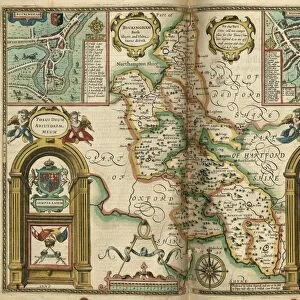
County Map of Buckinghamshire, c. 1777

![]()
Wall Art and Photo Gifts from Sheffield City Archives
County Map of Buckinghamshire, c. 1777
From The Large English Atlas: or, a new set of map of all the counties of England and Wales drawn from the several surveys which have been hitherto been published. With three general maps of England, Scotland and Ireland, from the latest and best authorities, by Emanuel Bowen, Thomas Kitchin and others. London, printed and sold by T. Bowles, [c.1777]
Original at Sheffield Libraries: 912 STF.
Dimensions of original: 77 x 58 cm
Sheffield City Archives and Local Studies Library has an unrivalled collection of images of Sheffield, England
Media ID 25437318
© Sheffield City Council - All Rights Reserved
Antique Map Bowens Map County Map Emanuel Bowen Old Map Thomas Kitchin Amersham Aylesbury Beaconsfield Bletchley Buckingham Buckinghamshire Burnham Chalfont St Giles Chalfont St Peter Chesham Denham Great Missenden High Wycombe Iver Marlow Milton Keynes
FEATURES IN THESE COLLECTIONS
> Arts
> Artists
> B
> Emanuel Bowen
> Arts
> Artists
> K
> Thomas Kitchin
> Europe
> Republic of Ireland
> Maps
> Europe
> United Kingdom
> England
> Buckinghamshire
> Amersham
> Europe
> United Kingdom
> England
> Buckinghamshire
> Aylesbury
> Europe
> United Kingdom
> England
> Buckinghamshire
> Beaconsfield
> Europe
> United Kingdom
> England
> Buckinghamshire
> Bletchley
> Europe
> United Kingdom
> England
> Buckinghamshire
> Buckingham
> Europe
> United Kingdom
> England
> Buckinghamshire
> Burnham
> Europe
> United Kingdom
> England
> Buckinghamshire
> Chalfont St Giles
> Sheffield City Archives
> Maps and Plans
> Bowen's County Maps, c. 1777
EDITORS COMMENTS
This antique map, titled "County Map of Buckinghamshire, c. 1777" is a fascinating piece of history that offers a glimpse into the past. Created by renowned cartographers Emanuel Bowen and Thomas Kitchin, this map was part of The Large English Atlas: or, a new set of maps of all the counties of England and Wales. Measuring an impressive 77 x 58 cm, this print showcases the intricate details and craftsmanship that went into creating such maps during the late 18th century. It features various towns and villages within Buckinghamshire, including Aylesbury, Amersham, Aston Clinton, Bletchley, Beaconsfield, Buckingham, Burnham, Chesham, Chepping Wycombe, and many more. The map also highlights notable landmarks like Campbell Park and Old Woughton while encompassing areas such as Milton Keynes and Marlow. Its historical significance lies not only in its accurate depiction but also in being drawn from several surveys conducted at that time. Preserved at Sheffield Libraries under reference number 912 STF. , this original print provides valuable insights into how people navigated through Buckinghamshire centuries ago. Whether you are a history enthusiast or simply appreciate vintage cartography artistry, this County Map will surely captivate your imagination with its rich historical context.
MADE IN THE UK
Safe Shipping with 30 Day Money Back Guarantee
FREE PERSONALISATION*
We are proud to offer a range of customisation features including Personalised Captions, Color Filters and Picture Zoom Tools
SECURE PAYMENTS
We happily accept a wide range of payment options so you can pay for the things you need in the way that is most convenient for you
* Options may vary by product and licensing agreement. Zoomed Pictures can be adjusted in the Basket.