Home > Science > Space Exploration > Satellite Imagery
Tropical Storm Lane
![]()

Wall Art and Photo Gifts from Science Photo Library
Tropical Storm Lane
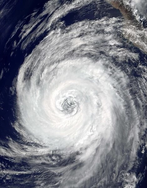
Tropical Storm Lane, true-colour satellite image. This cyclonic storm began as Tropical Depression 14-E on 5 September 2000, over the Pacific Ocean around 200 miles off the Mexican coast. It made a westwards clockwise loop and intensified into a hurricane by 10 September, as it headed towards Baja California, Mexico (top right). It brushed the coast with tropical storm winds, as stronger hurricane winds remained off-shore. It weakened to a tropical depression by 13 September, and broke up to bring heavy rain to the western USA from 14- 15 September. Image taken on 9 September 2000 by the Moderate Resolution Imaging Spectroradiometer (MODIS) aboard NASAs Terra satellite
Science Photo Library features Science and Medical images including photos and illustrations
Media ID 6375913
© NASA/SCIENCE PHOTO LIBRARY
2000 Atmosphere Atmospheric Baja California Climate Cloud Clouds Cloudy Cyclonic Extreme From Space Hurricane Imagery Meteorology Mexican Mexico Moderate Resolution Imaging Modis Pacific Ocean Radiometer Satellite Image September Severe Storm Spectrometer Spectroradiometer Spiral Swirl Swirling Terra True Colour Weather Wind Winds Windy Spiraling
EDITORS COMMENTS
This print captures the immense power and beauty of Tropical Storm Lane, a true force of nature. Taken on 9 September 2000 by NASA's Terra satellite, this true-colour satellite image showcases the swirling spiral of clouds that form the cyclonic storm. Originating as Tropical Depression 14-E over the Pacific Ocean, approximately 200 miles off the Mexican coast, Lane embarked on a westwards clockwise loop before intensifying into a hurricane by 10 September. Its trajectory set it on a collision course with Baja California, Mexico. As it approached landfall, Lane brushed the coast with tropical storm winds while stronger hurricane winds remained offshore. However, its strength gradually diminished and it weakened to a tropical depression by 13 September. Although no longer classified as a severe storm system at this point, its remnants brought heavy rainfall to parts of western USA from 14-15 September. The atmospheric conditions created an impressive spectacle in which wind and water merged in harmony. The imagery captured by MODIS (Moderate Resolution Imaging Spectroradiometer) aboard NASA's Terra satellite provides valuable insights into meteorology and climate patterns. This photograph serves as a reminder of both the destructive potential and awe-inspiring beauty found within our planet's natural phenomena.
MADE IN THE UK
Safe Shipping with 30 Day Money Back Guarantee
FREE PERSONALISATION*
We are proud to offer a range of customisation features including Personalised Captions, Color Filters and Picture Zoom Tools
SECURE PAYMENTS
We happily accept a wide range of payment options so you can pay for the things you need in the way that is most convenient for you
* Options may vary by product and licensing agreement. Zoomed Pictures can be adjusted in the Basket.

