Italy. True-colour satellite image centred on Italy and the central Mediterranean Sea

![]()
Wall Art and Photo Gifts from Science Photo Library
Italy. True-colour satellite image centred on Italy and the central Mediterranean Sea
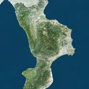
Italy. True-colour satellite image centred on Italy and the central Mediterranean Sea. North is at top. Water is blue, vegetation is green, snow is white and bare ground is light brown. The Alps are in the north of the image with a coating of snow. To the north-west of Italy are France and Switzerland, while the countries to the north- east include Austria, Slovenia and Croatia. In the Mediterranean Sea to the west of Italy are the islands of Corsica (upper, part of France) and Sardinia (lower, part of Italy). At bottom right is the Italian island of Sicily
Science Photo Library features Science and Medical images including photos and illustrations
Media ID 6350389
© PLANETOBSERVER/SCIENCE PHOTO LIBRARY
Alps Corsica Countries Country Earth Science From Space Italy Mediterranean Sea Nation Nations Sciences Sicily Slovenia
EDITORS COMMENTS
This breathtaking satellite image captures the beauty and diversity of Italy, showcasing its stunning landscapes and strategic location in the central Mediterranean Sea. The photograph reveals a true-colour representation of Italy, with vibrant blue waters surrounding the country and lush green vegetation dotting its terrain. Snow-capped peaks dominate the northern region, where the majestic Alps proudly stand. Italy's geographical position becomes evident as neighboring countries come into view. To the northwest lie France and Switzerland, while Austria, Slovenia, and Croatia can be seen to the northeast. The Mediterranean Sea stretches westward from Italy's shores, revealing two prominent islands: Corsica in the upper part (part of France) and Sardinia below (part of Italy). Finally, at bottom right is Sicily—a captivating Italian island that adds further charm to this already mesmerizing scene. This print from Science Photo Library not only showcases Italy's natural wonders but also serves as a testament to Earth science and our ability to capture such awe-inspiring images from space. It reminds us of how interconnected nations are within our planet's vast ecosystem while highlighting Italy's unique position as a gateway between Europe and Africa. Whether you're an admirer of geography or simply captivated by nature's splendor, this photograph offers an enchanting glimpse into one of Europe's most beloved nations—Italy.
MADE IN THE UK
Safe Shipping with 30 Day Money Back Guarantee
FREE PERSONALISATION*
We are proud to offer a range of customisation features including Personalised Captions, Color Filters and Picture Zoom Tools
SECURE PAYMENTS
We happily accept a wide range of payment options so you can pay for the things you need in the way that is most convenient for you
* Options may vary by product and licensing agreement. Zoomed Pictures can be adjusted in the Basket.