Home > Arts > Artists > M > Sebastian Munster
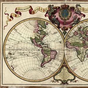
Map of the Americas, 1550

![]()
Wall Art and Photo Gifts from Science Photo Library
Map of the Americas, 1550
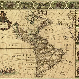
16th century map of the Americas. Published in 1550, this German map shows a rudimentary geography of the newly-discovered Americas. The inscriptions on South America are in German; the other place names are in Latin. Areas explored by the Spanish from the 1490s onwards included Cuba and Florida, as well as Central and South America. The area further north, in North America, was explored by the French in the 1520s and 1530s. To the west, Japan (known to Europeans from 1542) and India are incorrectly shown next to North America. This map, by the German cartographer Sebastian Munster (1489-1552), was published in Basel in an edition of his Cosmographia, the earliest German atlas
Science Photo Library features Science and Medical images including photos and illustrations
Media ID 1699847
© LIBRARY OF CONGRESS, GEOGRAPHY AND MAP DIVISION/SCIENCE PHOTO LIBRARY
1500s 16th Century Age Of Discovery Cartography Colonies Colony Continent Continental Continents Empire Exploration French German India Indian Japan Medieval Middle Ages New World North American South America South American Spanish 1550 Cosmographia New France Sebastian Munster
FEATURES IN THESE COLLECTIONS
> Arts
> Artists
> M
> Sebastian Munster
> Science Photo Library
> History
EDITORS COMMENTS
This 16th-century map of the Americas, published in 1550 by German cartographer Sebastian Munster, offers a glimpse into the rudimentary geography and exploration of the newly-discovered continent. The inscriptions on South America are written in German, while other place names are depicted in Latin. Spanish explorers had already ventured into Cuba, Florida, Central and South America since the late 15th century, as indicated on this historical document. Meanwhile, French expeditions during the early 1500s explored regions further north in North America. Interestingly, this map also reveals some misconceptions prevalent at that time. To the west of North America lie Japan (known to Europeans from 1542) and India; however, their placement is inaccurately portrayed here. Munster's Cosmographia atlas was one of Germany's earliest atlases and was published in Basel. This remarkable print not only showcases significant colonial powers such as Spain and France but also highlights Europe's expanding knowledge about distant lands during the Age of Discovery. It serves as a testament to humanity's relentless curiosity for exploration and understanding our world. The Science Photo Library presents this historic image capturing an era when cartography played a crucial role in shaping empires' ambitions and providing glimpses into far-off territories yet to be fully understood or explored.
MADE IN THE UK
Safe Shipping with 30 Day Money Back Guarantee
FREE PERSONALISATION*
We are proud to offer a range of customisation features including Personalised Captions, Color Filters and Picture Zoom Tools
SECURE PAYMENTS
We happily accept a wide range of payment options so you can pay for the things you need in the way that is most convenient for you
* Options may vary by product and licensing agreement. Zoomed Pictures can be adjusted in the Basket.