Home > Science > Space Exploration > Planets > Venus
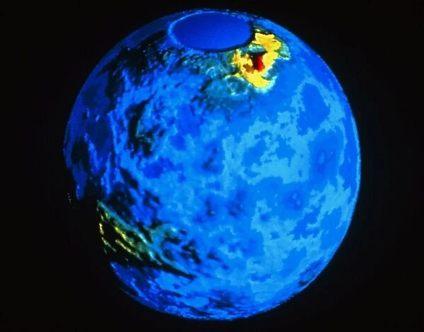
Global topographic map of Venus
![]()

Wall Art and Photo Gifts from Science Photo Library
Global topographic map of Venus
Colour-coded topographic map of the surface of Venus, compiled from radar data recorded by the Pioneer-Venus spacecraft. The smooth circle at top marks the north pole, an area not mapped by the spacecraft. Most of the planets surface is covered by relatively smooth plains, coloured blue in this image. Two large highland regions are visible (yellow), Ishtar Terra (upper left) and Aphrodite Terra (lower right). Ishtar Terra is a " continent" about the size of Australia, containing the Maxwell Montes (red), the highest mountains on Venus
Science Photo Library features Science and Medical images including photos and illustrations
Media ID 6426331
© NASA/SCIENCE PHOTO LIBRARY
Cosmology Planetary Venus Topographic Map
FEATURES IN THESE COLLECTIONS
> Science
> Space Exploration
> Pioneer
> Science
> Space Exploration
> Planets
> Venus
EDITORS COMMENTS
This print showcases a global topographic map of Venus, revealing the mesmerizing and diverse landscape of our neighboring planet. Compiled from radar data recorded by the Pioneer-Venus spacecraft, this colour-coded map offers an unprecedented glimpse into the surface features of Venus. The image highlights the vast expanse of relatively smooth plains that dominate most of Venus' surface, depicted in striking shades of blue. However, two prominent highland regions steal the spotlight with their vibrant yellow hues. Ishtar Terra, situated in the upper left corner resembling a massive continent comparable to Australia's size, captivates viewers with its intriguing topography. Within Ishtar Terra lies Maxwell Montes - majestic red peaks that stand as Venus' highest mountains. As we explore this extraterrestrial terrain through our eyes and imagination, it is important to note that there are areas yet uncharted by spacecrafts like Pioneer-Venus; one such region is marked by a smooth circle at the top denoting the north pole. This awe-inspiring visual representation not only ignites curiosity about our celestial neighbors but also serves as a testament to human ingenuity and technological advancements in space exploration. Let this remarkable print transport you on an interplanetary journey where beauty meets scientific discovery – unveiling secrets hidden within Venus' enigmatic landscapes.
MADE IN THE UK
Safe Shipping with 30 Day Money Back Guarantee
FREE PERSONALISATION*
We are proud to offer a range of customisation features including Personalised Captions, Color Filters and Picture Zoom Tools
SECURE PAYMENTS
We happily accept a wide range of payment options so you can pay for the things you need in the way that is most convenient for you
* Options may vary by product and licensing agreement. Zoomed Pictures can be adjusted in the Basket.


