Home > Arts > Landscape paintings > Waterfall and river artworks > River artworks
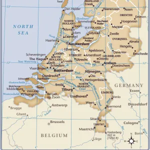
Dutch map of New Netherland and New England

![]()
Wall Art and Photo Gifts from North Wind
Dutch map of New Netherland and New England
New Netherland and New England, circa 1630.
Hand-colored 19th-century woodcut reproduction of DeLaets map
North Wind Picture Archives brings history to life with stock images and hand-colored illustrations
Media ID 5880982
© North Wind Picture Archives
1600s 17th Century America Cape Cod Colonial Connecticut Discover Dutch Dutch Colony Eastern English English Colony Exploration Explore Hudson River Lake Champlain Massachusetts New Amsterdam New England New Jersey New Netherland New World New York Rhode Island 1630 Long Island
FEATURES IN THESE COLLECTIONS
> Arts
> Landscape paintings
> Waterfall and river artworks
> River artworks
> Europe
> Netherlands
> Amsterdam
> Europe
> Netherlands
> Lakes
> Related Images
> Europe
> Netherlands
> Maps
> Europe
> Netherlands
> Rivers
> Europe
> United Kingdom
> England
> Lakes
> Europe
> United Kingdom
> England
> Maps
> Europe
> United Kingdom
> England
> Rivers
> Europe
> United Kingdom
> England
> York
> North Wind Picture Archives
> Exploration
> North Wind Picture Archives
> Maps
EDITORS COMMENTS
This vintage print showcases a Dutch map of New Netherland and New England, dating back to the 17th century. Hand-colored in the 19th century, this woodcut reproduction of DeLaet's map exudes a sense of heritage and tradition. The intricate illustration takes us on an exploration through time, revealing the early colonial history of America. The map encompasses various regions, including New York, Massachusetts, Connecticut, New Jersey, Rhode Island, and parts of present-day Vermont. It highlights significant landmarks such as Long Island and Cape Cod while tracing the course of the Hudson River and Lake Champlain. Notably featured are Fort Orange (present-day Albany) and New Amsterdam (now known as Manhattan), both prominent Dutch settlements during that era. This historical artifact offers a glimpse into the complex dynamics between English colonies and their Dutch counterparts in North America. It symbolizes an era when European powers vied for control over these newly discovered lands. As we admire this remarkable piece of artistry from North Wind Picture Archives, it serves as a reminder of our rich past and how far we have come since those early days of exploration. Whether displayed in homes or educational institutions alike, this print sparks curiosity about our collective history while celebrating the beauty found within cartography's artistic expression.
MADE IN THE UK
Safe Shipping with 30 Day Money Back Guarantee
FREE PERSONALISATION*
We are proud to offer a range of customisation features including Personalised Captions, Color Filters and Picture Zoom Tools
SECURE PAYMENTS
We happily accept a wide range of payment options so you can pay for the things you need in the way that is most convenient for you
* Options may vary by product and licensing agreement. Zoomed Pictures can be adjusted in the Basket.