
Maps Collection
Maps of Grenada North America are a collection that show the Caribbean island nation located in the southeastern Caribbean Sea
Choose a picture from our Maps Collection for your Wall Art and Photo Gifts
23 items


All Professionally Made to Order for Quick Shipping
-
Maps Collection
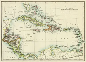
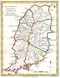
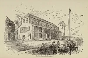
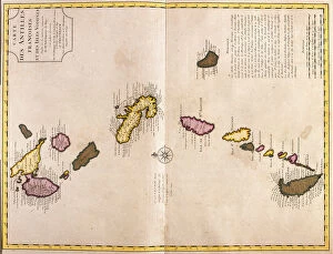
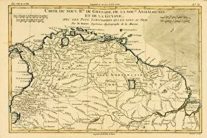
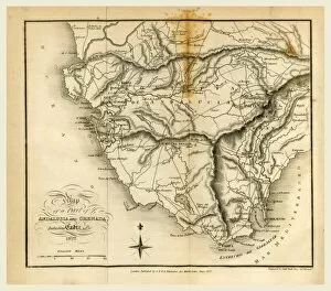
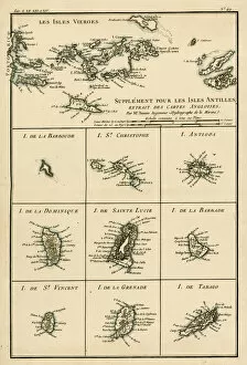
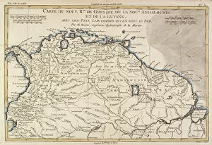
Maps of Grenada North America are a collection that show the Caribbean island nation located in the southeastern Caribbean Sea, and is located northwest of Trinidad and Tobago, and south of Saint Vincent and the Grenadines. The maps include detailed physical features such as mountains, rivers, lakes, coastlines, roads and cities. They also feature political boundaries between countries as well as international borders with Venezuela to the west and Barbados to the east. they also provide information about local climate zones including tropical rainforest areas in the north-east corner of Grenada. Other features include national parks, protected areas for wildlife conservation, airports and other points of interest for travelers visiting this beautiful island nation.
+
Our beautiful pictures are available as Framed Prints, Photos, Wall Art and Photo Gifts
The Maps of Grenada North America collection from Media Storehouse is a stunning compilation of vintage and contemporary maps that depict the island nation of Grenada in the Caribbean. Our collection features a range of maps, including topographical, political, and historical maps that showcase the diverse landscapes and cultural heritage of Grenada. Each map in our collection is carefully curated to offer a unique perspective on Grenada's geography, history, and culture. From detailed street maps to colorful illustrated maps depicting local flora and fauna, these prints are perfect for anyone looking to add some Caribbean flair to their home decor. Whether you're an avid traveler or simply appreciate beautiful cartography, the Maps of Grenada North America collection offers something for everyone. With high-quality printing and framing options available through our wall art and framed prints service, these maps make excellent gifts or additions to any personal art collection.
+
What are Maps of Grenada North America art prints?
Maps of Grenada North America art prints are high-quality reproductions of vintage and contemporary maps depicting the island nation of Grenada, located in the Caribbean Sea. These art prints showcase the topography, geography, and landmarks of Grenada in intricate detail, making them ideal for anyone interested in history or geography. These maps can be used as decorative pieces to add a touch of sophistication to any room. They also make great gifts for those who have an interest in cartography or travel. The Maps of Grenada North America art prints come in various sizes and styles to suit different preferences. Whether you're looking for a vintage map that captures the essence of old-world charm or a modern rendition that showcases current developments on the island, there is something for everyone. We offer a wide range of these beautiful art prints that are sure to impress anyone who sees them.
+
What Maps of Grenada North America art prints can I buy from Media Storehouse?
We offer a wide range of Maps of Grenada North America art prints that you can buy. These maps are available in various sizes and styles, including vintage, antique, and modern designs. You can choose from different types of maps such as topographical, political, physical, and satellite imagery. The Maps of Grenada North America art prints available at Media Storehouse are perfect for anyone who loves geography or history. They make great additions to any home or office decor and serve as educational tools for students studying the region's geography. Whether you're looking for a detailed map with all the cities and towns labeled or a more artistic representation of the area's landscape, we have something to offer. With their vast collection of high-quality prints sourced from renowned photographers and artists worldwide, you're sure to find the perfect map print that suits your taste and style preferences.
+
How do I buy Maps of Grenada North America art prints?
To buy maps of Grenada North America art prints from Media Storehouse, you can browse our extensive collection of artwork online. Once you have found the print that you like, simply add it to your cart and proceed to checkout. You will be prompted to enter your shipping and payment information before completing your purchase. We offer a variety of sizes for their prints, so make sure to select the size that best fits your needs. We also offer framing options if you prefer a ready-to-hang piece. If you have any questions or concerns about purchasing from Media Storehouse, they have a customer service team available to assist you. Simply reach out via email or phone and they will be happy to help. Buying maps of Grenada North America art prints from Media Storehouse is an easy process that allows you to bring beautiful artwork into your home or office space.
+
How much do Maps of Grenada North America art prints cost?
The cost of Maps of Grenada North America art prints varies depending on the size, quality, and type of print. Prices can range from affordable to expensive, depending on your budget and preferences. The good news is that you can find a wide selection of Maps of Grenada North America art prints at Media Storehouse, which offers high-quality reproductions for home or office decor. Whether you're looking for a vintage-style map or a modern interpretation, there are plenty of options to choose from. You can select from different sizes and finishes such as canvas or framed prints. Additionally, some prints may come with additional features like matting or mounting. The cost of Maps of Grenada North America art prints will depend on what you want in terms of style and quality. However, we offer an extensive collection that caters to various budgets without compromising on quality.
+
How will my Maps of Grenada North America art prints be delivered to me?
Your Maps of Grenada North America art prints will be delivered to you in a safe and secure manner. The delivery process is carefully handled by our team, ensuring that your artwork arrives at your doorstep in pristine condition. We use high-quality packaging materials to protect the print during transit. The prints are shipped flat or rolled depending on the size and type of paper used for printing. If it's a smaller print, it may be sent flat with additional cardboard backing for extra protection. Larger prints are usually rolled into sturdy tubes to prevent any damage during shipping. We work with reliable courier services who provide tracking information so you can monitor the progress of your shipment from dispatch until delivery. Once your order has been dispatched, we'll send you an email confirmation along with all relevant tracking details. We take great care in delivering your Maps of Grenada North America art prints safely and securely to ensure they arrive at their destination in perfect condition.