Home > Maps and Charts > World
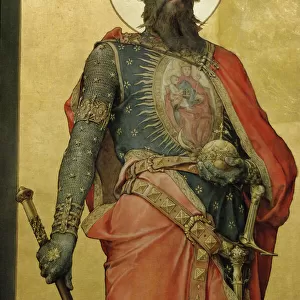
World Map / St Sever 11C

![]()
Wall Art and Photo Gifts from Mary Evans Picture Library
World Map / St Sever 11C
A world map according to Saint Sever, showing various countries, seas and rivers Date: 11th century
Mary Evans Picture Library makes available wonderful images created for people to enjoy over the centuries
Media ID 7140329
© Mary Evans Picture Library 2015 - https://copyrighthub.org/s0/hub1/creation/maryevans/MaryEvansPictureID/10113654
11th Countries Maps Rivers Seas Sever
EDITORS COMMENTS
1. Title: "A Glimpse into the Past: Saint Sever's 11th Century World Map" This image showcases a rare and intriguing artifact from the annals of history - a world map dating back to the 11th century, as depicted in the works of Saint Sever. The map, a testament to the curiosity and exploration of the medieval world, is a fascinating representation of the geographical knowledge available during that time. The map, adorned with meticulously drawn borders and labels, reveals a world vastly different from our own. Countries, seas, and rivers are depicted with varying degrees of accuracy, reflecting the limited yet growing understanding of the world during the Middle Ages. The map includes the known continents of Europe, Asia, Africa, and the Americas, as well as the Mediterranean Sea and various rivers, such as the Nile, Danube, and Rhine. Saint Sever, a monk and scholar from the monastery of Bec in Normandy, France, is believed to have created or commissioned this map. His works, which included geographical descriptions and maps, were influential in the development of European cartography. This map, in particular, demonstrates the progress made in geographical knowledge during the 11th century, as well as the curiosity and intellectual pursuits of the monks and scholars of the time. The intricate details and vibrant colors of this map transport us back to an era of exploration and discovery, offering a unique perspective on the world as it was known over 900 years ago. This artifact serves as a reminder of the rich history and cultural heritage that has shaped our understanding of the world and our place within it.
MADE IN THE UK
Safe Shipping with 30 Day Money Back Guarantee
FREE PERSONALISATION*
We are proud to offer a range of customisation features including Personalised Captions, Color Filters and Picture Zoom Tools
SECURE PAYMENTS
We happily accept a wide range of payment options so you can pay for the things you need in the way that is most convenient for you
* Options may vary by product and licensing agreement. Zoomed Pictures can be adjusted in the Basket.