Home > North America > United States of America > Maps
North Polar Region 1897 Date: 1897

![]()
Wall Art and Photo Gifts from Mary Evans Picture Library
North Polar Region 1897 Date: 1897
Mary Evans Picture Library makes available wonderful images created for people to enjoy over the centuries
Media ID 20184238
© The Pictures Now Image Collection / Bubblepunk
1897 Antiquarian Antique Earth Globe Including Journey Journeys Maps Polar Region Travels Treks Trip Trips Voyage Voyages
FEATURES IN THESE COLLECTIONS
> Maps and Charts
> World
> Mary Evans Prints Online
> Pictures Now
> North America
> United States of America
> Maps
EDITORS COMMENTS
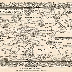
This antique print, dated 1897, showcases an intricately detailed map of the North Polar Region. The map, which is part of the Old Series of the United States Geographical Exploration and Surveying (USGS) collection, offers a glimpse into the world as it was understood during the late 19th century. The map includes various landmasses and islands, many of which were still being discovered and explored at the time. The map is particularly noteworthy for its inclusion of the Asian and European continents, highlighting the interconnectedness of the world during this period of intense exploration and discovery. The North Pole itself is depicted as a blank expanse, a testament to the challenges and mysteries that lay in wait for those brave enough to venture into the unknown. The map also features various journeys and voyages that had been undertaken in the region up to that point, including those of notable explorers such as Roald Amundsen, Robert Peary, and Frederick Cook. These treks are marked with red lines, adding an exciting narrative element to the map and underscoring the spirit of adventure that characterized the era. The map's intricate detail and historical significance make it a fascinating addition to any collection of antique maps or historical documents. It serves as a reminder of the incredible journeys and discoveries that shaped our understanding of the world, and the enduring allure of the North Polar Region as a place of mystery and exploration.
MADE IN THE UK
Safe Shipping with 30 Day Money Back Guarantee
FREE PERSONALISATION*
We are proud to offer a range of customisation features including Personalised Captions, Color Filters and Picture Zoom Tools
SECURE PAYMENTS
We happily accept a wide range of payment options so you can pay for the things you need in the way that is most convenient for you
* Options may vary by product and licensing agreement. Zoomed Pictures can be adjusted in the Basket.