Home > Europe > United Kingdom > England > Northamptonshire > Rothwell
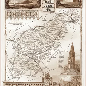
1840s Victorian Map of Northamptonshire

![]()
Wall Art and Photo Gifts from Mary Evans Picture Library
1840s Victorian Map of Northamptonshire
Mary Evans Picture Library makes available wonderful images created for people to enjoy over the centuries
Media ID 32350856
© The Keasbury-Gordon Photograph Archive / Mary Evans
1840s Daventry Northampton Northamptonshire Oundle Railways Rothwell Towcester Wellingborough
FEATURES IN THESE COLLECTIONS
> Europe
> United Kingdom
> England
> Maps
> Europe
> United Kingdom
> England
> Northamptonshire
> Daventry
> Europe
> United Kingdom
> England
> Northamptonshire
> Northampton
> Europe
> United Kingdom
> England
> Northamptonshire
> Old
> Europe
> United Kingdom
> England
> Northamptonshire
> Oundle
> Europe
> United Kingdom
> England
> Northamptonshire
> Rothwell
> Europe
> United Kingdom
> England
> Northamptonshire
> Towcester
> Europe
> United Kingdom
> England
> Northamptonshire
> Wellingborough
> Europe
> United Kingdom
> England
> Railways
> Maps and Charts
> Early Maps
> Mary Evans Prints Online
> New Images July 2023
EDITORS COMMENTS
Step back in time with this stunning 1840s Victorian map of Northamptonshire, a true vintage treasure from the Keasbury-Gordon Photograph Archive Collection. This beautifully detailed map showcases the county's charming towns and villages such as Northampton, Rothwell, Daventry, Towcester, Wellingborough, and Oundle, giving us a glimpse into England's past.
The intricate railway lines crisscrossing the map remind us of an era when train travel was at its peak, connecting communities and facilitating trade across the country. The Edwardian charm of this early map is evident in its elegant design and meticulous craftsmanship.
As you gaze upon this piece of history, you can almost imagine yourself wandering through the streets of these quaint English towns during a bygone era. The nostalgia evoked by this old county map is palpable, transporting us to a time when life moved at a slower pace and technology had yet to dominate our daily lives.
Whether you have a personal connection to Northamptonshire or simply appreciate historical artifacts, this vintage lantern slide print is sure to captivate your imagination and spark conversations about England's rich heritage. Add a touch of old-world charm to your home decor with this timeless piece from Mary Evans Prints Online.
MADE IN THE UK
Safe Shipping with 30 Day Money Back Guarantee
FREE PERSONALISATION*
We are proud to offer a range of customisation features including Personalised Captions, Color Filters and Picture Zoom Tools
SECURE PAYMENTS
We happily accept a wide range of payment options so you can pay for the things you need in the way that is most convenient for you
* Options may vary by product and licensing agreement. Zoomed Pictures can be adjusted in the Basket.