Home > Europe > United Kingdom > England > Kent > Hythe
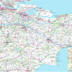
1840s Victorian Map of Kent

![]()
Wall Art and Photo Gifts from Mary Evans Picture Library
1840s Victorian Map of Kent
Mary Evans Picture Library makes available wonderful images created for people to enjoy over the centuries
Media ID 32350838
© The Keasbury-Gordon Photograph Archive / Mary Evans
1840s Canterbury Dover Folkstone Hythe Marsh Railways Romney Thanet Tunbridge Woolwich
FEATURES IN THESE COLLECTIONS
> Europe
> United Kingdom
> England
> Canterbury
> Europe
> United Kingdom
> England
> Kent
> Canterbury
> Europe
> United Kingdom
> England
> Kent
> Dover
> Europe
> United Kingdom
> England
> Kent
> Hythe
> Europe
> United Kingdom
> England
> Maps
> Europe
> United Kingdom
> England
> Railways
> Maps and Charts
> Early Maps
> Mary Evans Prints Online
> New Images July 2023
EDITORS COMMENTS
Step back in time with this stunning 1840s Victorian Map of Kent, a vintage piece that captures the intricate details of the county during this era. The map showcases towns such as Woolwich, Folkstone, Thanet, Canterbury, Romney Marsh, Hythe, Tunbridge, and Dover in exquisite detail.
This print is not just a map but a piece of history frozen in time. It gives us a glimpse into what life was like in Kent during the early 19th century. The Edwardian charm and old-world feel of the map transport us to a bygone era when railways were starting to crisscross through England.
The craftsmanship and attention to detail on this map are truly remarkable. Each line and symbol tells a story about the landscape and infrastructure of Kent at that time. From bustling cities to serene countryside areas, every corner of the county is meticulously depicted on this map.
Whether you have roots in Kent or simply appreciate historical artifacts, this print is sure to be a conversation starter in any room. Display it proudly on your wall and let its beauty spark curiosity and admiration for days gone by. Let yourself get lost in the intricate streets and landmarks of 1840s Kent with this Victorian Map print from The Keasbury-Gordon Photograph Archive Collection at Mary Evans Prints Online.
MADE IN THE UK
Safe Shipping with 30 Day Money Back Guarantee
FREE PERSONALISATION*
We are proud to offer a range of customisation features including Personalised Captions, Color Filters and Picture Zoom Tools
SECURE PAYMENTS
We happily accept a wide range of payment options so you can pay for the things you need in the way that is most convenient for you
* Options may vary by product and licensing agreement. Zoomed Pictures can be adjusted in the Basket.