Home > Europe > United Kingdom > England > Cheshire > Audlem
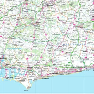
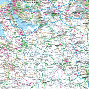
1840s Victorian Map of Cheshire

![]()
Wall Art and Photo Gifts from Mary Evans Picture Library
1840s Victorian Map of Cheshire
Mary Evans Picture Library makes available wonderful images created for people to enjoy over the centuries
Media ID 32350782
© The Keasbury-Gordon Photograph Archive / Mary Evans
1840s Altrincham Birkenhead Brighton Cheshire Chester Railways Sandbach Stockport Warrington Audlem Tarporley
FEATURES IN THESE COLLECTIONS
> Europe
> United Kingdom
> England
> Brighton & Hove
> Europe
> United Kingdom
> England
> Cheshire
> Audlem
> Europe
> United Kingdom
> England
> Cheshire
> Chester
> Europe
> United Kingdom
> England
> Cheshire
> Sandbach
> Europe
> United Kingdom
> England
> Cheshire
> Stockport
> Europe
> United Kingdom
> England
> Cheshire
> Tarporley
> Europe
> United Kingdom
> England
> Cheshire
> Warrington
> Europe
> United Kingdom
> England
> Chester
> Europe
> United Kingdom
> England
> Maps
> Europe
> United Kingdom
> England
> Railways
> Mary Evans Prints Online
> New Images July 2023
EDITORS COMMENTS
Step back in time with this stunning 1840s Victorian Map of Cheshire, a true piece of history preserved for all to admire. This vintage lantern slide captures the intricate details of the county, from Chester to Birkenhead, New Brighton to Audlem. The map showcases the bustling towns and picturesque countryside that make up this charming region of England.
As you gaze upon this Edwardian-era map, you can almost imagine what life was like in Cheshire during the early 19th century. The railway lines crisscrossing the county hint at a time when travel was becoming more accessible and connected communities in new ways.
From Warrington to Stockport, Altrincham to Sandbach, Tarporley to every corner of Cheshire, each town is carefully labeled and placed on the map with precision. It's a reminder of how important geography was in shaping society and commerce during this period.
Whether you have roots in Cheshire or simply appreciate historical artifacts, this print is sure to spark your curiosity and transport you back in time. Add it to your collection today and marvel at the beauty and complexity of this 1840s Victorian Map of Cheshire by The Keasbury-Gordon Photograph Archive Collection from Mary Evans Prints Online.
MADE IN THE UK
Safe Shipping with 30 Day Money Back Guarantee
FREE PERSONALISATION*
We are proud to offer a range of customisation features including Personalised Captions, Color Filters and Picture Zoom Tools
SECURE PAYMENTS
We happily accept a wide range of payment options so you can pay for the things you need in the way that is most convenient for you
* Options may vary by product and licensing agreement. Zoomed Pictures can be adjusted in the Basket.