Home > Europe > United Kingdom > England > Essex > Coggeshall
Coggeshall, Essex

![]()
Wall Art and Photo Gifts from Mary Evans Picture Library
Coggeshall, Essex
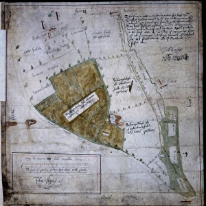
Map of Coggeshall, Essex, by John Agas, 21 May 1619 Date: 21st May 1619
Mary Evans Picture Library makes available wonderful images created for people to enjoy over the centuries
Media ID 7404179
© Mary Evans Picture Library 2015 - https://copyrighthub.org/s0/hub1/creation/maryevans/MaryEvansPictureID/10474488
FEATURES IN THESE COLLECTIONS
> Europe
> United Kingdom
> England
> Essex
> Coggeshall
> Maps and Charts
> Related Images
> Mary Evans Prints Online
> National Archives
EDITORS COMMENTS
1. Title: "A 17th Century Exploration of Coggeshall, Essex: John Agas' Detailed Map from 1619" This exquisite map, created by the renowned English cartographer John Agas on the 21st of May in 1619, offers a fascinating glimpse into the layout and topography of Coggeshall, a historic market town nestled in the heart of Essex, England. The map, which measures approximately 1034 x 1318 pixels, is a testament to the meticulous cartographic skills of the time and provides valuable insights into the town's urban planning and geographical features. The map is adorned with intricate details, such as the winding streets, the River Colne, and the various water mills and windmills that dotted the landscape. Agas' attention to detail extends to the inclusion of significant landmarks, including the Parish Church of St Peter and St Paul, the Market Place, and the town's various guildhalls. The map also reveals the town's defensive structures, including the ancient walls and gates, which would have protected Coggeshall from potential invaders. The presence of these fortifications underscores the importance of Coggeshall as a strategic location during the 17th century. Furthermore, the map provides evidence of the town's economic activity, with the depiction of various markets and fairs, as well as the presence of mills and other industrial sites. The map's meticulous annotation and clear, detailed illustrations make it an invaluable resource for historians, genealogists, and anyone interested in the history of Coggeshall and the wider Essex region. In summary, this stunning 17th-century map of Coggeshall, Essex, by John Agas, offers a unique and captivating window into the history and layout of this historic town. Its intricate details and valuable insights make it an essential addition to any collection of historical maps or local history resources.
MADE IN THE UK
Safe Shipping with 30 Day Money Back Guarantee
FREE PERSONALISATION*
We are proud to offer a range of customisation features including Personalised Captions, Color Filters and Picture Zoom Tools
SECURE PAYMENTS
We happily accept a wide range of payment options so you can pay for the things you need in the way that is most convenient for you
* Options may vary by product and licensing agreement. Zoomed Pictures can be adjusted in the Basket.