Home > Europe > United Kingdom > Wales > Maps
Canals and rivers of England and Wales

![]()
Wall Art and Photo Gifts from Mary Evans Picture Library
Canals and rivers of England and Wales
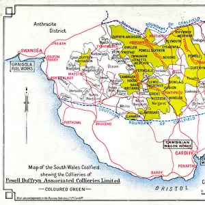
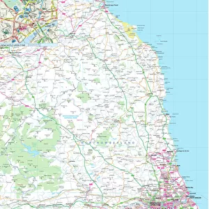
Map of canals and navigable rivers of England and Wales, c1910 Date: c. 1910
Mary Evans Picture Library makes available wonderful images created for people to enjoy over the centuries
Media ID 7401937
© Mary Evans Picture Library 2015 - https://copyrighthub.org/s0/hub1/creation/maryevans/MaryEvansPictureID/10474745
FEATURES IN THESE COLLECTIONS
> Europe
> United Kingdom
> England
> Maps
> Europe
> United Kingdom
> England
> Rivers
> Europe
> United Kingdom
> Wales
> Maps
> Europe
> United Kingdom
> Wales
> Rivers
> Maps and Charts
> Wales
> Mary Evans Prints Online
> National Archives
EDITORS COMMENTS
This map print from the early 1910s showcases the extensive network of canals and navigable rivers that crisscrossed England and Wales during the 1900s. The intricate detail of the map reveals the intricate web of waterways that connected various towns and cities, enabling the efficient transportation of goods and people before the widespread use of railways. The map covers a vast area, stretching from the Scottish Borders in the north to the English Channel in the south, and from the Irish Sea in the west to the North Sea in the east. The major rivers, such as the Thames, Severn, and Mersey, are depicted in their entirety, while numerous smaller rivers and canals are also represented. The intricate network of canals, which includes the Grand Union Canal, the Trent and Mersey Canal, and the Leeds and Liverpool Canal, is particularly noteworthy. These man-made waterways allowed for the transportation of coal, iron, and other heavy goods over long distances, contributing significantly to the industrial growth of the region. The map also reveals the rich history of the waterways, with various towns and cities marked, as well as important landmarks and points of interest. The intricate detail of the map is a testament to the extensive planning and engineering that went into creating and maintaining the network of canals and rivers that once formed the backbone of transportation in England and Wales. This map is a fascinating snapshot of a bygone era, offering a unique perspective on the history of transportation in England and Wales during the early 1900s. It is a must-have for anyone with an interest in history, geography, or the industrial heritage of the region.
MADE IN THE UK
Safe Shipping with 30 Day Money Back Guarantee
FREE PERSONALISATION*
We are proud to offer a range of customisation features including Personalised Captions, Color Filters and Picture Zoom Tools
SECURE PAYMENTS
We happily accept a wide range of payment options so you can pay for the things you need in the way that is most convenient for you
* Options may vary by product and licensing agreement. Zoomed Pictures can be adjusted in the Basket.