Home > Africa > Egypt > Maps
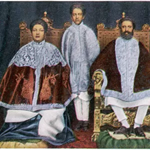
Poster Print : Map of Ancient Egypt


![]()
Poster Prints from Mary Evans Picture Library
Map of Ancient Egypt
Map of Ancient Egypt. Date: 1814
Mary Evans Picture Library makes available wonderful images created for people to enjoy over the centuries
Media ID 11575345
© Mary Evans / Grenville Collins Postcard Collection
1814 Arabia Arabian Cancer Chart Delta Ethiopia Inferior Maps Mediterranean Nile Superior Tropic
A1 (84.1 x 59.4cm) Poster Print
Discover the rich history and grandeur of Ancient Egypt with our exquisite Map of Ancient Egypt poster print. This captivating reproduction, dating back to 1814, is sourced from the extensive Mary Evans Prints Online archive. Bring the mysteries of the Nile Valley into your home or office with this intricately detailed map, showcasing the major cities, temples, and landmarks of this ancient civilization. Impress your guests with this stunning piece of historical art, now available as a high-quality poster print from Media Storehouse. Experience the magic of the past, right in your living space.
A1 Poster (84.1 x 59.4cm, 33.1" x 23.4" inches) printed on 170gsm Satin Poster Paper. Securely packaged, rolled and inserted into a strong mailing tube and shipped tracked. Poster Prints are of comparable archival quality to our Photographic prints, they are simply printed on thinner Poster Paper. Whilst we only use Photographic Prints in our frames, you can frame Poster Prints if they are carefully supported to prevent sagging over time.
Poster prints are budget friendly enlarged prints in standard poster paper sizes (A0, A1, A2, A3 etc). Whilst poster paper is sometimes thinner and less durable than our other paper types, they are still ok for framing and should last many years. Our Archival Quality Photo Prints and Fine Art Paper Prints are printed on higher quality paper and the choice of which largely depends on your budget.
Estimated Image Size (if not cropped) is 59.4cm x 74.9cm (23.4" x 29.5")
Estimated Product Size is 59.4cm x 84.1cm (23.4" x 33.1")
These are individually made so all sizes are approximate
Artwork printed orientated as per the preview above, with portrait (vertical) orientation to match the source image.
FEATURES IN THESE COLLECTIONS
> Africa
> Egypt
> Related Images
> Africa
> Ethiopia (Abyssinia)
> Related Images
> Africa
> Ethiopia
> Related Images
> Maps and Charts
> Early Maps
EDITORS COMMENTS
This map, created in 1814, offers a glimpse into the ancient world of Egypt, a land rich in history and culture that continues to fascinate scholars and travelers alike. The map, titled "A New and Correct Chart of Egypt and Nubia," was produced during the classical era of Egyptology, a time when European interest in the ancient civilization was at its peak. The map's intricate details reveal the vast expanse of Egypt, stretching from the First Cataract of the Nile in the south to the Delta region in the north, and from the Mediterranean Sea in the north to the Red Sea and the borders of Arabia in the east. The mighty Nile River, the lifeblood of ancient Egypt, snakes its way through the heart of the country, providing a vital transportation route and irrigating the fertile lands along its banks. The map also highlights the important cities and landmarks of ancient Egypt, including Memphis, Thebes, and Alexandria, as well as the two cataracts that marked the dividing line between the Upper and Lower Kingdoms: the First Cataract, located near Aswan, and the Second Cataract, near Khartoum. The map also indicates the locations of the Tropic of Cancer and the two Niles: the White Nile, which originates in Lake Victoria in present-day Uganda, and the Blue Nile, which originates in Ethiopia. This map, with its meticulous attention to detail and historical accuracy, provides a valuable window into the ancient world of Egypt, a world that continues to captivate and inspire us with its rich history and cultural heritage.
MADE IN THE UK
Safe Shipping with 30 Day Money Back Guarantee
FREE PERSONALISATION*
We are proud to offer a range of customisation features including Personalised Captions, Color Filters and Picture Zoom Tools
SECURE PAYMENTS
We happily accept a wide range of payment options so you can pay for the things you need in the way that is most convenient for you
* Options may vary by product and licensing agreement. Zoomed Pictures can be adjusted in the Basket.