Home > Africa > Tunisia > Maps
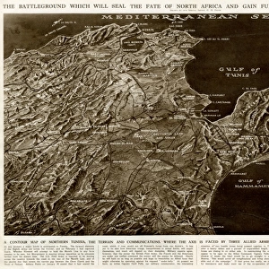
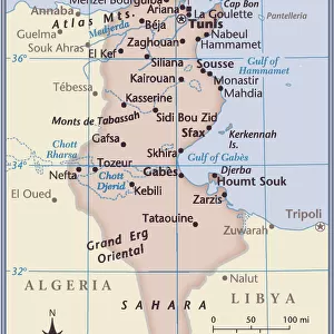
Map of Tunisia by G. H. Davis

![]()
Wall Art and Photo Gifts from Mary Evans Picture Library
Map of Tunisia by G. H. Davis
Map of the Front Zone in Tunisia, North Africa, immediately prior to the capture of Mateur, opening the road to Tebourba and Djedeida for Allied forces during the Second World War. Date: 1943
Mary Evans Picture Library makes available wonderful images created for people to enjoy over the centuries
Media ID 14133375
© Illustrated London News Ltd/Mary Evans
1943 Allied Allies Axis Capture Davis Forces Gulf Mediterranean Opening Success Tunis Tunisia Zone Hammamet
FEATURES IN THESE COLLECTIONS
> Maps and Charts
> Early Maps
> Maps and Charts
> World
EDITORS COMMENTS
This historic map, titled "Map of the Front Zone in Tunisia, North Africa," was created by renowned cartographer G.H. Davis in 1943. The map provides a detailed view of the North African country of Tunisia during a pivotal moment in World War II. The map's focus is on the 'Front Zone,' the area of intense military activity between the Allied and Axis forces during the North African Campaign. At the time of this map's creation, the Allied forces, led by the United States and Great Britain, were making significant strides in their efforts to push back the Axis powers, who were led by Germany and Italy. The capture of the port city of Mateur, marked on the map, was a crucial turning point in the campaign. The successful capture of Mateur opened up the road to Tebourba and Djedeida, allowing the Allies to advance further into Tunisia and ultimately secure the region. The map offers a fascinating glimpse into the strategic landscape of the war in North Africa. Key features depicted include the Mediterranean Sea and the Tunisian coastline, with the Gulf of Hammamet and the coastal towns of Bizerta and Tunis prominently displayed. The map also highlights various military installations, roads, and other important landmarks. The map's historical significance is underscored by its creation date, 1943, a year that saw the Allied forces make significant gains against the Axis powers in North Africa. The map is a testament to the meticulous work of cartographers like G.H. Davis, who played a vital role in helping the Allied forces navigate the complex and ever-changing battlefield. This map is an essential addition to any collection of World War II history or cartography.
MADE IN THE UK
Safe Shipping with 30 Day Money Back Guarantee
FREE PERSONALISATION*
We are proud to offer a range of customisation features including Personalised Captions, Color Filters and Picture Zoom Tools
SECURE PAYMENTS
We happily accept a wide range of payment options so you can pay for the things you need in the way that is most convenient for you
* Options may vary by product and licensing agreement. Zoomed Pictures can be adjusted in the Basket.