Home > Asia > Kyrgyzstan > Maps
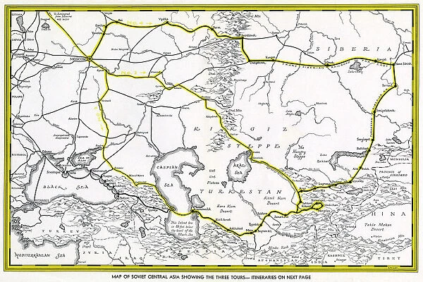
Map of Soviet Central Asia
![]()

Wall Art and Photo Gifts from Mary Evans Picture Library
Map of Soviet Central Asia
Map of Soviet Central Asia - showing marked tour routes. Date: 1933
Mary Evans Picture Library makes available wonderful images created for people to enjoy over the centuries
Media ID 11552332
© Mary Evans / Grenville Collins Postcard Collection
1933 Borders Chart Kyrgyz Kyrgyzstan Mapping Routes Siberia Soviet Steppe Territory Turkestan Kirgiz
FEATURES IN THESE COLLECTIONS
> Asia
> Kyrgyzstan
> Maps
> Maps and Charts
> Early Maps
EDITORS COMMENTS
1. Title: "Exploring the Uncharted Terrains of Soviet Central Asia: A 1933 Map Reveals Marked Tour Routes This vintage map print, dated 1933, showcases the expansive territory of Soviet Central Asia during the era of the Russian Empire's expansion. The map, a testament to the era's exploration and cartographic advancements, highlights the marked tour routes across the region. Central Asia, a vast and historically rich landmass, is depicted in this map with meticulous detail. The map covers the territories of present-day Kazakhstan, Kyrgyzstan, Tajikistan, Turkmenistan, and Uzbekistan, as well as parts of western China and Siberia. The map's intricate lines and borders reveal the political landscape of the time, with the Soviet Union's influence extending far and wide. The map's primary focus, however, is the marked tour routes, which crisscross the Central Asian steppe. These routes, indicated by solid lines, were likely used for travel and transportation during the 1930s. The map's inscription, "Tourist Routes," suggests that this map was intended for travelers and adventurers seeking to explore the unexplored territories of the Soviet Union. The map's creation in 1933, during the height of the Soviet era, provides a fascinating glimpse into the history of Central Asia. This era was marked by significant cultural and political changes, as the Soviet Union sought to assert its influence over the region. The map serves as a reminder of the rich history and diverse cultures that have shaped Central Asia, making it an essential resource for historians, geographers, and anyone interested in the region's past. In conclusion, this map print of Soviet Central Asia, with its marked tour routes, offers a captivating glimpse into the history and exploration of a region that continues to fascinate and intrigue us today. Its intricate details and historical significance make it a valuable addition to any collection of vintage maps or Central Asian studies.
MADE IN THE UK
Safe Shipping with 30 Day Money Back Guarantee
FREE PERSONALISATION*
We are proud to offer a range of customisation features including Personalised Captions, Color Filters and Picture Zoom Tools
SECURE PAYMENTS
We happily accept a wide range of payment options so you can pay for the things you need in the way that is most convenient for you
* Options may vary by product and licensing agreement. Zoomed Pictures can be adjusted in the Basket.

