Home > Europe > Russia > Maps
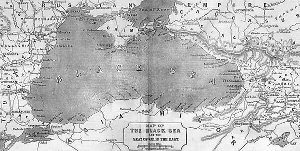
Map of the Black Sea and the Crimea, 1854
![]()

Wall Art and Photo Gifts from Mary Evans Picture Library
Map of the Black Sea and the Crimea, 1854
Engraving of a map of the area around the Black Sea with the borders between Turkey and Russia, showing the disputed Crimea region. Date: 1854
Mary Evans Picture Library makes available wonderful images created for people to enjoy over the centuries
Media ID 14113952
© Illustrated London News Ltd/Mary Evans
1854 Area Borders Crimea Disputed Region
FEATURES IN THESE COLLECTIONS
> Asia
> Turkey
> Related Images
EDITORS COMMENTS
1. Title: A Contested Region: The Black Sea and the Crimea, 1854 Description: This engraving depicts a detailed map of the Black Sea and the surrounding areas, with a particular focus on the disputed region of Crimea. The map, created in 1854, shows the borders between Turkey and Russia, highlighting the contentious area that would soon become the center of the Crimean War. The Black Sea, a vital waterway connecting Europe and Asia, is depicted with its intricate coastlines and numerous islands. The Crimean Peninsula, located at the northwestern end of the Black Sea, is shown with its strategic ports and fortifications. Background: The Crimean War (1853-1856) was a major conflict between Russia and an alliance of European powers, including France, the United Kingdom, and Sardinia. The primary cause of the war was Russia's expansionist policies, particularly its desire to gain control of the Crimean Peninsula, which was then part of the Ottoman Empire. The map reflects the political tensions of the time, as both Russia and Turkey vied for influence in the region. Historical Significance: The Crimean War was a pivotal moment in European history, marking the end of the Eastern Question and the beginning of a new era of European intervention in the Middle East. The war also led to significant advances in military technology and medical care, as well as increased awareness of the importance of sanitation and public health. The map serves as a visual representation of the complex geopolitical landscape of the mid-19th century and the tensions that would eventually lead to conflict. Condition: The map is in good condition, with some minor wear and foxing along the edges. The engraving is clear and detailed, making it an excellent resource for scholars and historians studying the Crimean War and the broader context of European imperialism in the 19th century. Accession Number: ILN:ID.21-DEC-07/MARY-EVANS-1017617 Source: Mary Evans Picture Library, London, UK.
MADE IN THE UK
Safe Shipping with 30 Day Money Back Guarantee
FREE PERSONALISATION*
We are proud to offer a range of customisation features including Personalised Captions, Color Filters and Picture Zoom Tools
FREE COLORIZATION SERVICE
You can choose advanced AI Colorization for this picture at no extra charge!
SECURE PAYMENTS
We happily accept a wide range of payment options so you can pay for the things you need in the way that is most convenient for you
* Options may vary by product and licensing agreement. Zoomed Pictures can be adjusted in the Basket.

