Home > Africa > Algeria > Constantine
Map / Africa / Algeria C1850

![]()
Wall Art and Photo Gifts from Mary Evans Picture Library
Map / Africa / Algeria C1850
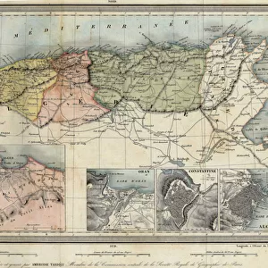
Algeria under French rule, divided into three provinces of Oran, Algiers and Constantine Date: circa 1850
Mary Evans Picture Library makes available wonderful images created for people to enjoy over the centuries
Media ID 7133789
© Mary Evans Picture Library 2015 - https://copyrighthub.org/s0/hub1/creation/maryevans/MaryEvansPictureID/10046918
1850 Algeria Algiers C1850 Constantine Divided Maps Oran Provinces Rule
FEATURES IN THESE COLLECTIONS
> Africa
> Algeria
> Constantine
EDITORS COMMENTS
This map print, dated circa 1850, offers a glimpse into the historical division of Algeria under French rule. At the time, Algeria was not yet an official French colony but was instead governed as three distinct provinces: Oran, Algiers, and Constantine. The map illustrates the geographical boundaries of each province, with the Mediterranean Sea to the north, the Sahara Desert to the south, and the Atlas Mountains to the southwest. The French influence is evident in the map's title, which is written in both French and Latin, reflecting the European perspective of the region. The intricate detailing of the map, including the depiction of major cities, rivers, and mountains, showcases the extensive exploration and cartographic knowledge of the time. The map serves as a poignant reminder of the complex history of Algeria and its relationship with France. The French conquest of Algeria began in 1830 and lasted until 1962, making it one of the longest colonial occupations in history. The division of Algeria into provinces was a strategic move to facilitate the administration and control of the vast territory. This map print is an essential addition to any collection of historical maps or those interested in the history of Africa, colonialism, or cartography. Its intricate detailing and historical significance make it a fascinating and educational piece that can transport us back in time to an era of exploration and discovery.
MADE IN THE UK
Safe Shipping with 30 Day Money Back Guarantee
FREE PERSONALISATION*
We are proud to offer a range of customisation features including Personalised Captions, Color Filters and Picture Zoom Tools
SECURE PAYMENTS
We happily accept a wide range of payment options so you can pay for the things you need in the way that is most convenient for you
* Options may vary by product and licensing agreement. Zoomed Pictures can be adjusted in the Basket.