Home > Europe > United Kingdom > England > London > River Thames
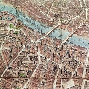
London in 1593

![]()
Wall Art and Photo Gifts from Mary Evans Picture Library
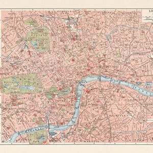
London in 1593
Map of centre of London in 1593 Date: 1593
Mary Evans Picture Library makes available wonderful images created for people to enjoy over the centuries
Media ID 14145210
© Mary Evans Picture Library
FEATURES IN THESE COLLECTIONS
> Europe
> United Kingdom
> England
> London
> River Thames
> Europe
> United Kingdom
> England
> Maps
> Europe
> United Kingdom
> England
> Rivers
> Maps and Charts
> Early Maps
EDITORS COMMENTS
1. Title: A Glimpse into the Past: London in 1593 - A Historical Map of the Centre Date: 1593 Description: Step back in time with this print of a historical map depicting the centre of London as it appeared in the year 1593. This intricately detailed representation of the bustling metropolis, located in the heart of England, offers a unique perspective into the history and development of one of the world's most iconic cities. The map, which dates back to the 16th century, showcases the River Thames meandering through the heart of London, with several key landmarks and structures clearly visible. The City of London, the historic core of the city, is depicted with its narrow, winding streets and prominent churches, including St. Paul's Cathedral and Temple Church. The map also highlights several important locations, such as the Royal Exchange, the residence of Queen Elizabeth I, and the Tower of London, a historic fortress that has stood guard over the city for over 1,000 years. The map's meticulous detail and accurate portrayal of the city's layout provide a fascinating glimpse into the daily life and architecture of London during the Elizabethan era. The map serves as a testament to the rich history and enduring allure of London, which continues to captivate visitors from around the world. Whether you are an avid historian, a student of architecture, or simply someone with a passion for the past, this print is a must-have addition to any collection. As you explore the intricacies of this historical map, you'll be transported back in time to an era of exploration, discovery, and innovation. Let the story of London in 1593 unfold before your eyes and ignite your imagination.
MADE IN THE UK
Safe Shipping with 30 Day Money Back Guarantee
FREE PERSONALISATION*
We are proud to offer a range of customisation features including Personalised Captions, Color Filters and Picture Zoom Tools
SECURE PAYMENTS
We happily accept a wide range of payment options so you can pay for the things you need in the way that is most convenient for you
* Options may vary by product and licensing agreement. Zoomed Pictures can be adjusted in the Basket.