Home > North America > Canada > Maps
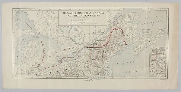
The Lake Frontier of Canada and the United States
![]()

Wall Art and Photo Gifts from Mary Evans Picture Library
The Lake Frontier of Canada and the United States
The Lake Frontier of Canada and the United States. From a collection of maps relevant to campaigns between 1794-1815. From the collection of the former Buffs Regimental Museum. Associated with Wars of the French Revolution (1793-1802) and Napoleonic Wars (1803-1815). Date: 1815
Mary Evans Picture Library makes available wonderful images created for people to enjoy over the centuries
Media ID 14403880
© The National Army Museum / Mary Evans Picture Library
1793 1794 1802 1803 1813 1815 Associated Buffs Campaigns Frontier Maps Napoleonic Regimental Revolution Wars
FEATURES IN THESE COLLECTIONS
> Maps and Charts
> Related Images
> North America
> Canada
> Lakes
> Related Images
> North America
> Canada
> Maps
EDITORS COMMENTS
This map print, titled "The Lake Frontier of Canada and the United States," dates back to 1815 and is a significant historical artifact from the collection of the former Buffs Regimental Museum. This map holds immense relevance to the campaigns that took place between 1794 and 1815, particularly during the Wars of the French Revolution (1793-1802) and the Napoleonic Wars (1803-1815). The map provides a detailed and intricate depiction of the North American frontier, focusing on the Great Lakes region, which was a strategic battleground during this period. The borderlands between Canada and the United States are clearly demarcated, highlighting the complexities of the geopolitical situation during that time. The map's historical significance is further underscored by its association with the Buffs Regimental Museum, a military institution with a rich history that can be traced back to the late 18th century. The Buffs, also known as the Royal East Kent Regiment, played a crucial role in various military conflicts, including the American War of 1812. This map serves as a testament to the intricate political and military landscape of the time, providing valuable insights into the strategic considerations and challenges faced by military leaders during the French Revolutionary and Napoleonic Wars. The detailed topography, place names, and fortifications depicted in the map offer a unique perspective on the geography of the region and the military campaigns that unfolded there. The Lake Frontier of Canada and the United States is not only an essential historical document but also a beautiful work of cartography that captures the imagination and transports us back in time to an era of great political and military upheaval.
MADE IN THE UK
Safe Shipping with 30 Day Money Back Guarantee
FREE PERSONALISATION*
We are proud to offer a range of customisation features including Personalised Captions, Color Filters and Picture Zoom Tools
SECURE PAYMENTS
We happily accept a wide range of payment options so you can pay for the things you need in the way that is most convenient for you
* Options may vary by product and licensing agreement. Zoomed Pictures can be adjusted in the Basket.

