Home > Europe > Belgium > Maps
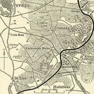
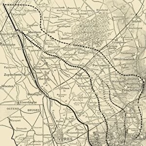
The Fighting Line in Flanders, 1915

![]()
Wall Art and Photo Gifts from Mary Evans Picture Library
The Fighting Line in Flanders, 1915
Areas of possession between the German and Allied armies on the Western front by the autumn of 1915. Despite the advances made by the Germans at Ypres, these were counterbalanced by the advance made at Neuve Chapelle and Loos.
1915
Mary Evans Picture Library makes available wonderful images created for people to enjoy over the centuries
Media ID 14143111
© Mary Evans Picture Library
Allied Areas Flanders Maps Stalemate Trench Warfare
FEATURES IN THESE COLLECTIONS
> Maps and Charts
> World
EDITORS COMMENTS
The Fighting Line in Flanders, 1915: A Delicate Balance of Power This evocative map from 1915 illustrates the complex and intricate battlelines that crisscrossed the landscape of Flanders during the First World War. By the autumn of that year, the Western Front had reached a stalemate, with both the German and Allied armies locked in a brutal and seemingly endless struggle for territory. The map reveals the precarious balance of power that existed between the two sides. The Germans had made significant gains at Ypres, pushing the Allied lines back and capturing key strategic positions. However, these advances were counterbalanced by the Allied counteroffensives at Neuve Chapelle and Loos. The intricate network of trenches and fortifications that snaked across the landscape is a testament to the brutal and unyielding nature of trench warfare. The map also highlights the devastating impact of the conflict on the civilian population, with large swathes of land marked as 'evacuated' or 'destroyed'. Despite the seemingly intractable nature of the stalemate, both sides continued to launch offensives in an attempt to gain the upper hand. The fighting in Flanders would continue for another three years, with neither side able to achieve a decisive victory. The map serves as a poignant reminder of the human cost of the conflict, with countless lives lost in the pursuit of territory and strategic advantage. The map also underscores the importance of military intelligence and strategic planning in the conduct of war. Both sides relied on accurate and up-to-date information about the enemy's positions and movements to inform their own tactical decisions. The intricacies of the battlelines depicted in the map reflect the complex and ever-changing nature of the conflict on the Western Front.
MADE IN THE UK
Safe Shipping with 30 Day Money Back Guarantee
FREE PERSONALISATION*
We are proud to offer a range of customisation features including Personalised Captions, Color Filters and Picture Zoom Tools
SECURE PAYMENTS
We happily accept a wide range of payment options so you can pay for the things you need in the way that is most convenient for you
* Options may vary by product and licensing agreement. Zoomed Pictures can be adjusted in the Basket.