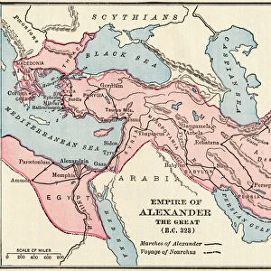
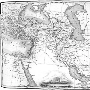
The Empires of Persia and of Alexander the Great

![]()
Wall Art and Photo Gifts from Mary Evans Picture Library
The Empires of Persia and of Alexander the Great
A map of the Persian Empire about 500BC, and the Empire of Alexander the Great in 323 BC, as envisaged in 1899 AD. The battle field of Gaugamela, the line of march to Persepolis and the march to the north east in pursuit of Darius are indicated
Mary Evans Picture Library makes available wonderful images created for people to enjoy over the centuries
Media ID 14130009
© Mary Evans Picture Library
500bc Alexander Darius Empires Persepolis Persia Persian Pursuit Gaugamela
EDITORS COMMENTS
This map print depicts the Empires of Persia and of Alexander the Great as they stood in the pivotal years of 500 BC and 323 BC. The Persian Empire, at the height of its power under King Xerxes I, is shown in its full glory, stretching from modern-day Egypt and Turkey in the west, to India in the east. The mighty rivers of the ancient world, the Nile and the Indus, mark the western and eastern boundaries of this vast realm. In stark contrast, the Empire of Alexander the Great, established after his decisive victory at the Battle of Gaugamela in 331 BC, is shown in its infancy. The line of march from Gaugamela to the legendary city of Persepolis, the former capital of the Persian Empire, is clearly indicated. Alexander's relentless pursuit of the Persian king, Darius III, is also illustrated, leading to the northeast, towards modern-day Afghanistan and Pakistan. The Battle of Gaugamela, fought in October 333 BC, marked a turning point in world history. Alexander's victory not only ended the Persian Empire but also opened up the eastern world to the Greeks. The map beautifully illustrates the vast territories conquered by Alexander, which would come to be known as the Hellenistic World. This map, created in 1899 AD, offers a fascinating glimpse into the historical geography of the ancient world, providing valuable insights into the political and military strategies of two of history's most remarkable leaders. The intricate details and meticulous labeling make this map a must-have for historians, educators, and anyone with an interest in ancient history.
MADE IN THE UK
Safe Shipping with 30 Day Money Back Guarantee
FREE PERSONALISATION*
We are proud to offer a range of customisation features including Personalised Captions, Color Filters and Picture Zoom Tools
FREE COLORIZATION SERVICE
You can choose advanced AI Colorization for this picture at no extra charge!
SECURE PAYMENTS
We happily accept a wide range of payment options so you can pay for the things you need in the way that is most convenient for you
* Options may vary by product and licensing agreement. Zoomed Pictures can be adjusted in the Basket.