Home > Europe > France > Paris > Maps
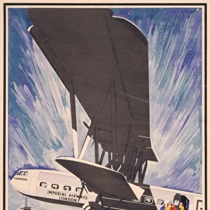
Cover design, Imperial Airways map, 1933

![]()
Wall Art and Photo Gifts from Mary Evans Picture Library
Cover design, Imperial Airways map, 1933
Cover design, Imperial Airways map of air routes, 1933, price two shillings.
1933
Mary Evans Picture Library makes available wonderful images created for people to enjoy over the centuries
Media ID 14360697
© Onslows Auctioneers / Mary Evans Picture Library
1933 Airways Basle Brussels Cologne Koln Price Routes Shillings Stylised Zurich Deco
FEATURES IN THESE COLLECTIONS
> Europe
> France
> Paris
> Maps
> Europe
> Germany
> Cologne (Koln)
> Europe
> Switzerland
> Maps
> Europe
> Switzerland
> Zurich
> Europe
> United Kingdom
> England
> London
> Related Images
EDITORS COMMENTS
this vintage print showcases the cover design of an Imperial Airways map from 1933. The design is a stunning example of the Art Deco style, with its harmonious blend of geometric shapes, bold lines, and a palette of soothing grey, blue, and white tones. The central focus of the cover is a stylized representation of an aeroplane soaring through the sky, its wings outstretched and propellers in motion, symbolizing the spirit of adventure and progress embodied by air travel during this era. The map itself is a testament to the extensive reach of Imperial Airways' passenger services, covering various destinations across Europe. London, the United Kingdom's capital city, is prominently featured at the heart of the map, with key European cities such as Paris in France, Basle and Zurich in Switzerland, Brussels in Belgium, and Cologne (Koln) in Germany, all connected by intricate, winding lines that represent the air routes. The map is priced at two shillings, reflecting the affordability and accessibility of air travel during this period. This piece of history transports us back to an age of glamour and excitement, when the world seemed smaller and the possibilities for exploration seemed endless. Imperial Airways was a British airline that operated from 1924 to 1974, and this map serves as a fascinating glimpse into the company's rich history and the evolution of air travel during the early 20th century. This print is an essential addition to any collection focusing on aviation history, graphic design, or vintage travel memorabilia. This image is available for licensing through Onslows Auctioneers and Mary Evans Picture Library.
MADE IN THE UK
Safe Shipping with 30 Day Money Back Guarantee
FREE PERSONALISATION*
We are proud to offer a range of customisation features including Personalised Captions, Color Filters and Picture Zoom Tools
SECURE PAYMENTS
We happily accept a wide range of payment options so you can pay for the things you need in the way that is most convenient for you
* Options may vary by product and licensing agreement. Zoomed Pictures can be adjusted in the Basket.