Home > Europe > France > Canton > Belfort
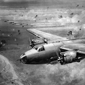
Contour map of Western Front by G. H. Davis

![]()
Wall Art and Photo Gifts from Mary Evans Picture Library
Contour map of Western Front by G. H. Davis
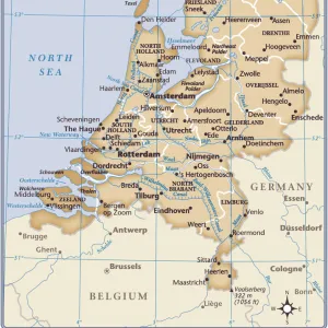
The Western Front: a contour map showing the area of the general Allied offensive at this stage of the Second World War. Showing the Siegfried Line, the supply port of Antwerp, the British and American fronts, and the Belfort Gap. Date: 1944
Mary Evans Picture Library makes available wonderful images created for people to enjoy over the centuries
Media ID 14134826
© Illustrated London News Ltd/Mary Evans
1944 Allied Allies Antwerp Area Belfort Contour Davis Fronts Holland Luxembourg Maps Netherlands Offensive Position Positions Siegfried Supply
FEATURES IN THESE COLLECTIONS
> Europe
> France
> Canton
> Belfort
> Europe
> Luxembourg
> Maps
> Europe
> Netherlands
> Maps
> Europe
> Switzerland
> Maps
> Maps and Charts
> Early Maps
> Maps and Charts
> Luxembourg
EDITORS COMMENTS
This contour map, created by renowned cartographer G.H. Davis in 1944, offers a unique perspective on the Western Front during the Second World War. The intricate details of the terrain reveal the strategic positions and movements of the Allied forces as they waged their offensive against the Axis powers in Europe. At the heart of the map lies the Siegfried Line, a formidable defensive structure fortified by the Germans to protect their western border. The Allied forces, determined to breach this line, are depicted advancing from various directions, with the British and American fronts clearly marked. The map also highlights the crucial supply port of Antwerp in Belgium, which played a vital role in the logistical support of the Allied forces. The map extends from the North Sea in the north to the Swiss border in the south, providing a comprehensive view of the war-torn regions in Holland, Luxembourg, France, and Germany. The Belfort Gap, a critical passage through the Vosges Mountains, is also shown, illustrating the importance of controlling this area for both the Allied and Axis forces. This historical map serves as a testament to the complexities of the Second World War and the strategic maneuvers that shaped its outcome. It offers a fascinating glimpse into the geographical and military challenges faced by the Allied forces during their offensive in 1944. With its meticulous detail and clear labeling, this map is an essential resource for scholars, historians, and anyone interested in the history of the Second World War in Europe.
MADE IN THE UK
Safe Shipping with 30 Day Money Back Guarantee
FREE PERSONALISATION*
We are proud to offer a range of customisation features including Personalised Captions, Color Filters and Picture Zoom Tools
SECURE PAYMENTS
We happily accept a wide range of payment options so you can pay for the things you need in the way that is most convenient for you
* Options may vary by product and licensing agreement. Zoomed Pictures can be adjusted in the Basket.