Home > Aerial Photography > Related Images
Technique Instructions for Overlapping Photos in a Mosai?

![]()
Wall Art and Photo Gifts from Mary Evans Picture Library
Technique Instructions for Overlapping Photos in a Mosai?
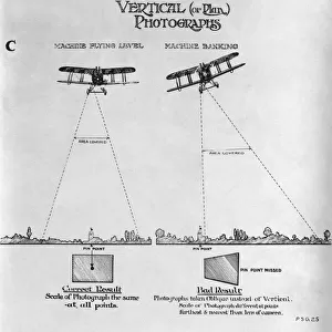
Technique Instructions for Overlapping Photos in a Mosaic Pattern for Aerial Photography Mapping - Early Years of Aerial-Photography History - Instructions Date: 1910s
Mary Evans Picture Library makes available wonderful images created for people to enjoy over the centuries
Media ID 18412920
© aviation-images.com / Mary Evans Picture Library
Air To Ground Archive Days Histories Olden Past Rafaerial
FEATURES IN THESE COLLECTIONS
> Aerial Photography
> Related Images
> Mary Evans Prints Online
> Aviation Images
EDITORS COMMENTS
1. Title: Technique Instructions for Overlapping Photos in a Mosaic Pattern for Aerial Photography: A Glimpse into the Early Years of Aerial Reconnaissance (1910s, UK) 2.. This print showcases a rare and intriguing set of instructions from the early years of aerial photography, specifically focusing on the technique used for creating mosaic patterns from overlapping aerial photographs during the 1910s in the United Kingdom. The Royal Flying Corps (RFC), the precursor to the Royal Air Force (RAF), revolutionized military intelligence gathering through the innovative use of aerial reconnaissance. The instructions in this print illustrate the meticulous process of aligning and overlapping photographs taken from an airborne perspective to create a comprehensive and accurate mosaic representation of the ground below. This technique, essential for mapping and military intelligence, was a significant advancement in the field of aerial photography during this period. The vintage aesthetic of this print, with its aged paper texture and the delicate, hand-drawn illustrations, transports us back to the olden days of aerial photography. The historical significance of this print lies in its unique insight into the past, offering a glimpse into the early stages of aerial photography and its role in shaping military strategy and intelligence gathering. This print is an invaluable archival resource, providing a fascinating look into the techniques and methods used during the formative years of aerial photography. It serves as a testament to the ingenuity and innovation of the pioneers in this field, who paved the way for the sophisticated aerial imaging technologies we have today. This print is available as a rights-managed image from Mary Evans Prints Online, offering a unique addition to any collection focused on the history of aerial photography, military history, or the history of technology.
MADE IN THE UK
Safe Shipping with 30 Day Money Back Guarantee
FREE PERSONALISATION*
We are proud to offer a range of customisation features including Personalised Captions, Color Filters and Picture Zoom Tools
FREE COLORIZATION SERVICE
You can choose advanced AI Colorization for this picture at no extra charge!
SECURE PAYMENTS
We happily accept a wide range of payment options so you can pay for the things you need in the way that is most convenient for you
* Options may vary by product and licensing agreement. Zoomed Pictures can be adjusted in the Basket.