Home > Europe > United Kingdom > England > London > Transport > Railway
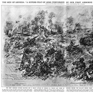
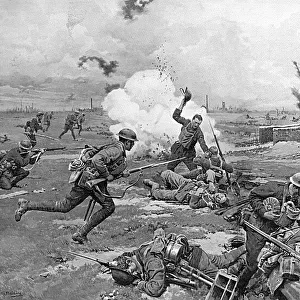
The Advance into Holland, WW2

![]()
Wall Art and Photo Gifts from Mary Evans Picture Library
The Advance into Holland, WW2
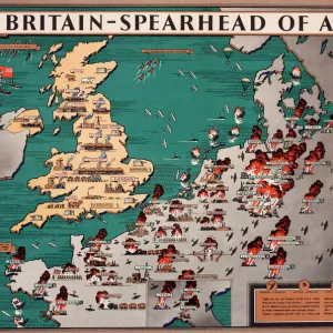
The Advance into Holland during the Second World War -- the Second Armys dash towards Nijmegen and Arnhem, and the crossing of the Belgian and Dutch water lines. Showing an annotated diagram of the great surge forward of the Allied Armies towards Eindhoven and Nijmegen, looking northwards. Date: 1944
Mary Evans Picture Library makes available wonderful images created for people to enjoy over the centuries
Media ID 14232535
© Illustrated London News Ltd/Mary Evans
1944 Advance Allied Allies Annotated Armies Arnhem Belgian Canal Corridor Dash Diagram Eindhoven Fields Forward Holland Netherlands Nijmegen Northwards Shelling Strategy Surge Tank Tanks
FEATURES IN THESE COLLECTIONS
> Europe
> Netherlands
> Arnhem
> Europe
> Netherlands
> Eindhoven
> Europe
> Netherlands
> Nijmegen
> Europe
> Netherlands
> Railways
> Europe
> United Kingdom
> England
> London
> Transport
> Railway
EDITORS COMMENTS
The Advance into Holland: A Strategic Turning Point in World War II This evocative photograph print captures the pivotal moment in the Allied advance towards the heart of Nazi-occupied Europe during World War II. The year is 1944, and the scene unfolds in the Netherlands, as the Second Army, led by British and Canadian forces, makes a daring dash towards the cities of Nijmegen and Arnhem. The annotated diagram illustrates the great surge forward, with the Allied forces pushing northwards towards their objectives. The corridor of land between the Belgian and Dutch water lines became the focus of intense fighting, as the Allies sought to establish a foothold in Europe and cut off the German supply lines. The advance was marked by a series of fierce battles, with the Allied forces encountering strong German resistance. The diagram reveals the strategic importance of key locations, such as the towns of Eindhoven and Nijmegen, and the vital transportation routes, including roads, railways, and canals. Tanks and other military vehicles are shown making their way through the fields and across the waterways, as the Allied forces pressed onwards. The advance into Holland was a crucial turning point in the war, as it marked the first major Allied offensive on the Western Front since the D-Day landings in Normandy. Despite initial successes, the operation ultimately failed to meet its objectives, and the Allies were forced to retreat. However, the battle proved to be a valuable learning experience, and paved the way for future victories in the European theater. This photograph print offers a unique glimpse into the history of World War II, providing a visual representation of the complex military strategies and tactics employed by the Allied forces during their advance into the Netherlands. It is a poignant reminder of the sacrifices made by the brave men and women who fought to secure freedom and democracy in Europe during the 1940s.
MADE IN THE UK
Safe Shipping with 30 Day Money Back Guarantee
FREE PERSONALISATION*
We are proud to offer a range of customisation features including Personalised Captions, Color Filters and Picture Zoom Tools
FREE COLORIZATION SERVICE
You can choose advanced AI Colorization for this picture at no extra charge!
SECURE PAYMENTS
We happily accept a wide range of payment options so you can pay for the things you need in the way that is most convenient for you
* Options may vary by product and licensing agreement. Zoomed Pictures can be adjusted in the Basket.