Home > Arts > Artists > S > Bernard Sleigh
A Conjectural Picture Map of Birmingham In 1730

![]()
Wall Art and Photo Gifts from MapSeeker
A Conjectural Picture Map of Birmingham In 1730
This is a striking colourful picture map of Birmingham in 1730, originally imagined & drawn from city records by Bernard Sleigh and lettered by I.A. Ellis, 1923. Originally printed by the Kynoch Press A.D. 1924, and published by Cornish Bros. Limited 39 New Street. This is a wonderfully detailed colourful pictorial map showing roads, the river Rea, principal buildings and the many dwellings, artisans workshops at a time when Birmingham rural aspect was about to transform into an industrial town rapidly growing outwards consuming the then far off villages that now form part of what is now the countries second city
Welcome to the Mapseeker Image library and enter an historic gateway to one of the largest on-line collections of Historic Maps, Nostalgic Views, Vista's and Panorama's from a World gone by.
Media ID 20347731
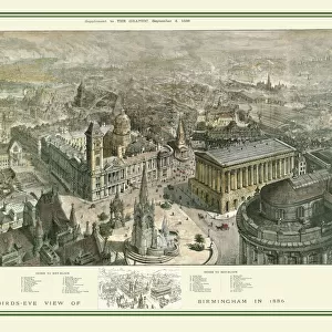
Birmingham Birmingham Map Birds Eye View
FEATURES IN THESE COLLECTIONS
> Arts
> Artists
> S
> Bernard Sleigh
> Arts
> Photorealistic artworks
> Detailed art pieces
> Masterful detailing in art
> Maps and Charts
> Related Images
> MapSeeker
> British Town And City Plans
> English & Welsh PORTFOLIO
> MapSeeker
> Pictorial Maps and Pictorial History
EDITORS COMMENTS
This print showcases a conjectural picture map of Birmingham in 1730, offering a vivid glimpse into the city's past. Originally envisioned and sketched by Bernard Sleigh from official city records, this masterpiece was meticulously lettered by I. A. Ellis in 1923. The Kynoch Press brought it to life with their printing expertise in 1924, while Cornish Bros. Limited published it on New Street. Immerse yourself in the intricate details of this colorful pictorial map as it unveils the roads, river Rea, prominent structures, and countless dwellings that once defined Birmingham's rural landscape. At this pivotal moment in history, the town was on the cusp of an industrial revolution that would rapidly expand its boundaries and engulf neighboring villages—transforming it into what is now known as the country's second-largest city. From a bird's eye view perspective, this panoramic map offers a unique vantage point to explore old Birmingham—a time capsule frozen within ink and paper. Delve into its enchanting streetscapes and artisan workshops; imagine bustling activity where tranquility now reigns supreme. As you gaze upon this mesmerizing birds-eye view of Birmingham, let your imagination soar through time and space—unearthing stories hidden within each stroke of Bernard Sleigh's brush. This remarkable piece transcends mere cartography; it is an invitation to rediscover our heritage and appreciate how far we have come since those transformative days.
MADE IN THE UK
Safe Shipping with 30 Day Money Back Guarantee
FREE PERSONALISATION*
We are proud to offer a range of customisation features including Personalised Captions, Color Filters and Picture Zoom Tools
SECURE PAYMENTS
We happily accept a wide range of payment options so you can pay for the things you need in the way that is most convenient for you
* Options may vary by product and licensing agreement. Zoomed Pictures can be adjusted in the Basket.