Home > Arts > Photorealistic artworks > Detailed art pieces > Masterful detailing in art
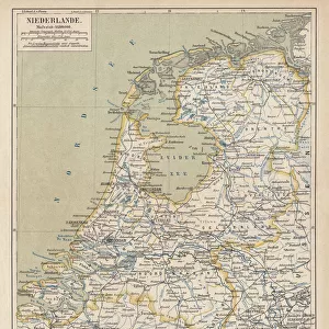
Old Map of Holland 1852 by Henry George Collins

![]()
Wall Art and Photo Gifts from MapSeeker
Old Map of Holland 1852 by Henry George Collins
This is a finely detailed map of Holland remastered from a rare Atlas of the World published in 1852 by Henry George Collins. Although these Henry Collins produced maps of the highest quality in his time unfortunately not the same could be said in terms of his business success. His maps were later obtained by the famous Stanford Map Company and used in their publications
Welcome to the Mapseeker Image library and enter an historic gateway to one of the largest on-line collections of Historic Maps, Nostalgic Views, Vista's and Panorama's from a World gone by.
Media ID 20347271
© Mapseeker Publishing Ltd
Collins Collins Atlas Collins Atlas Map Collins Map
FEATURES IN THESE COLLECTIONS
> Arts
> Photorealistic artworks
> Detailed art pieces
> Masterful detailing in art
> Maps and Charts
> Related Images
> Maps and Charts
> World
> MapSeeker
> Maps of Europe
> Maps of Holland or the Netherlands
EDITORS COMMENTS
This beautifully preserved print showcases an exquisite "Old Map of Holland 1852" by the talented cartographer Henry George Collins. Remastered from a rare Atlas of the World published in 1852, this map provides a fascinating glimpse into the historical geography of Holland during that era. Henry George Collins was renowned for his exceptional craftsmanship and attention to detail, evident in every inch of this meticulously crafted map. Although his maps were highly regarded for their quality, unfortunately, he did not achieve equal success in terms of business ventures. However, fate intervened as these remarkable maps found new life when they were acquired by the prestigious Stanford Map Company. Recognizing their value and significance, the company incorporated them into their own publications, ensuring that Collins' work would continue to be appreciated and admired by generations to come. As we gaze upon this image, we are transported back in time to witness Holland's geographical landscape as it existed over a century ago. Each contour line and intricate illustration tells a story of exploration and discovery. Whether you have an affinity for history or simply appreciate fine cartography, this old Dutch map is sure to captivate your imagination with its rich details and timeless charm. It serves as both a testament to Henry George Collins' talent as well as a window into Holland's past.
MADE IN THE UK
Safe Shipping with 30 Day Money Back Guarantee
FREE PERSONALISATION*
We are proud to offer a range of customisation features including Personalised Captions, Color Filters and Picture Zoom Tools
SECURE PAYMENTS
We happily accept a wide range of payment options so you can pay for the things you need in the way that is most convenient for you
* Options may vary by product and licensing agreement. Zoomed Pictures can be adjusted in the Basket.