Home > Europe > France > Heritage Sites > Palace and Park of Fontainebleau
France 1851

![]()
Wall Art and Photo Gifts from MapSeeker
France 1851
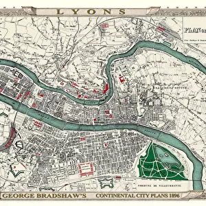
A fine facimile artworked from an antique original map of France, issued as part of the 1851 edition of John Tallis and Companys " The Illustrated Atlas and Modern History of the World". This early map of France shows France in provinces without the County (Comte) de Nice of the Duchy of Savoy (Savoie) prior to the 1860 Treaty of Turin when these territories were ceded to France. Vignettes: Garden of the Palais Royal; Calais Harbour; The Bridge of Toulouse; Palace of Fontainebleau. Railways are now well established and shown
Welcome to the Mapseeker Image library and enter an historic gateway to one of the largest on-line collections of Historic Maps, Nostalgic Views, Vista's and Panorama's from a World gone by.
Media ID 20347672
© Mapseeker Publishing Ltd
John Tallis John Tallis Map Tallis Map
FEATURES IN THESE COLLECTIONS
> Arts
> Artists
> T
> John Tallis
> Europe
> France
> Canton
> Savoie
> Europe
> France
> Heritage Sites
> Palace and Park of Fontainebleau
> Europe
> Italy
> Piedmont
> Turin
> Maps and Charts
> Early Maps
> MapSeeker
> Maps of Europe
> Maps of France PORTFOLIO
EDITORS COMMENTS
This stunning print captures a fine facsimile artworked from an antique original map of France dating back to 1851. Part of the renowned "The Illustrated Atlas and Modern History of the World" by John Tallis and Company, this early map showcases France in its provincial divisions, excluding the County (Comte) de Nice of the Duchy of Savoy (Savoie). It's worth noting that these territories were later incorporated into France following the signing of the 1860 Treaty of Turin. The intricate details on this vintage map are truly captivating. Vignettes adorn its borders, showcasing iconic landmarks such as the Garden of the Palais Royal, Calais Harbour, The Bridge of Toulouse, and Palace of Fontainebleau. These vignettes provide glimpses into different aspects that make France so enchanting. Furthermore, this historic map highlights how railways have become well-established throughout France at that time. The railway lines depicted on this map serve as a testament to progress and connectivity during this era. Overall, this print serves as both a visual delight for history enthusiasts and a valuable piece for collectors interested in old maps or French heritage. With its rich historical significance and exquisite artistry by John Tallis and John Rapkin, it is sure to be cherished by anyone with an appreciation for cartography or those seeking to add a touch of elegance to their space.
MADE IN THE UK
Safe Shipping with 30 Day Money Back Guarantee
FREE PERSONALISATION*
We are proud to offer a range of customisation features including Personalised Captions, Color Filters and Picture Zoom Tools
SECURE PAYMENTS
We happily accept a wide range of payment options so you can pay for the things you need in the way that is most convenient for you
* Options may vary by product and licensing agreement. Zoomed Pictures can be adjusted in the Basket.