Home > Europe > United Kingdom > England > Wells
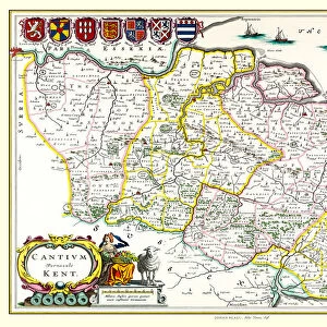
Old County Map of Kent 1836 by Thomas Moule

![]()
Wall Art and Photo Gifts from MapSeeker
Old County Map of Kent 1836 by Thomas Moule
This is a fine decorative reproduction County Map of Kent from the First Edition series of Thomas Moule Maps, originally Published in 1836. The well-known series of County Maps which are known as Moules feature beautiful vignette views and were first published in separate sections for each county in 1830-32, they were then published in collected form in a two-volume work: The English Counties Delineated: or a Topographical Description of England: Illustrated by a Complete Series of County Maps by Thomas Moule: London: Published by George Virtue 1836
Welcome to the Mapseeker Image library and enter an historic gateway to one of the largest on-line collections of Historic Maps, Nostalgic Views, Vista's and Panorama's from a World gone by.
Media ID 20347907
© Mapseeker Publishing Ltd
County Map County Map Of England English County Map Historic Map Moule Map Old County Map Old English County Map Old Moule Map Thomas Moule Thomas Moule Map
FEATURES IN THESE COLLECTIONS
> Arts
> Artists
> M
> Thomas Moule
> Europe
> United Kingdom
> England
> Kent
> Related Images
> Europe
> United Kingdom
> England
> London
> Towns
> Welling
> Europe
> United Kingdom
> England
> Maps
> Europe
> United Kingdom
> England
> Wells
> Maps and Charts
> Early Maps
> Maps and Charts
> Related Images
> MapSeeker
> Maps from the British Isles
> England and Counties PORTFOLIO
EDITORS COMMENTS
This exquisite print showcases the "Old County Map of Kent 1836" by Thomas Moule, a renowned cartographer of his time. Originally published as part of the First Edition series in 1836, this decorative reproduction captures the beauty and historical significance of Moule's work. Moule's County Maps are widely recognized for their intricate vignette views and attention to detail. This particular map was initially released in separate sections for each county between 1830-32 before being compiled into a two-volume masterpiece titled "The English Counties Delineated: or a Topographical Description of England". Published by George Virtue in London, this comprehensive collection became an invaluable resource for those seeking to explore and understand the diverse landscapes and regions within England. Kent, known for its rich history and picturesque countryside, is beautifully depicted on this historic map. Every corner reveals fascinating details about towns, villages, rivers, roads, and landmarks that have shaped the county over centuries. As you delve into this piece of artistry by Thomas Moule, you will be transported back in time to an era when maps were not just navigational tools but also works of art. Whether you are a history enthusiast or simply appreciate fine craftsmanship, this old county map serves as a testament to both Thomas Moule's talent as a cartographer and George Virtue's commitment to preserving our cultural heritage through printed works like these. Display it proudly on your wall or gift it to someone who shares your passion for history; either
MADE IN THE UK
Safe Shipping with 30 Day Money Back Guarantee
FREE PERSONALISATION*
We are proud to offer a range of customisation features including Personalised Captions, Color Filters and Picture Zoom Tools
SECURE PAYMENTS
We happily accept a wide range of payment options so you can pay for the things you need in the way that is most convenient for you
* Options may vary by product and licensing agreement. Zoomed Pictures can be adjusted in the Basket.