Home > Europe > United Kingdom > Scotland > Aberdeenshire > Aberdeen
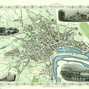
Poster Print : Old Map of Aberdeen 1851 by John Tallis
![]()

Poster Prints from MapSeeker
Old Map of Aberdeen 1851 by John Tallis
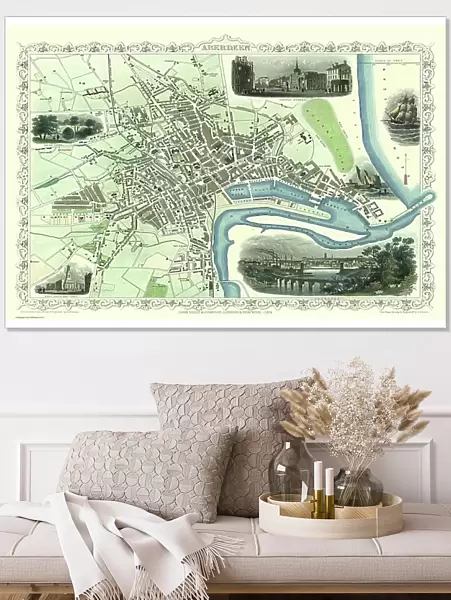
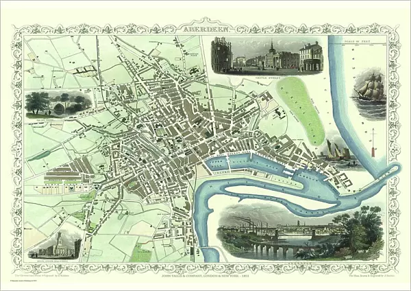
Aberdeen in Scotland nestled on the River Dee with its famous Victorian Park and Harbour, John TallisAEs 1851 town plan perfectly captures this historic Scottish town during mid Victorian times. To the bottom right of the plan is a most attractive illustration of Aberdeen. At the top of the plan there is a view towards Castle Street. The other illustrations are of Old Don Bridge, North Church on King Street and a sailing ship on the German Ocean
Welcome to the Mapseeker Image library and enter an historic gateway to one of the largest on-line collections of Historic Maps, Nostalgic Views, Vista's and Panorama's from a World gone by.
Media ID 20347713
Historic Map John Tallis John Tallis Map Old Town Plan Tallis Map Aberdeen
A1 (84.1 x 59.4cm) Poster Print
Introducing the Media Storehouse collection of Old Map of Aberdeen 1851 by John Tallis poster prints. Step back in time and explore the historic Scottish town of Aberdeen as it was during the mid-Victorian era. Nestled on the banks of the River Dee, this captivating town plan by renowned cartographer John Tallis showcases Aberdeen's famous Victorian Park and Harbour. Rich in history and character, this beautifully detailed map is a must-have for anyone with an appreciation for Scottish heritage or a love for antique maps. Add a touch of history and charm to your home or office with this stunning Old Map of Aberdeen 1851 by John Tallis poster print.
A1 Poster (84.1 x 59.4cm, 33.1" x 23.4" inches) printed on 170gsm Satin Poster Paper. Securely packaged, rolled and inserted into a strong mailing tube and shipped tracked. Poster Prints are of comparable archival quality to our Photographic prints, they are simply printed on thinner Poster Paper. Whilst we only use Photographic Prints in our frames, you can frame Poster Prints if they are carefully supported to prevent sagging over time.
Poster prints are budget friendly enlarged prints in standard poster paper sizes (A0, A1, A2, A3 etc). Whilst poster paper is sometimes thinner and less durable than our other paper types, they are still ok for framing and should last many years. Our Archival Quality Photo Prints and Fine Art Paper Prints are printed on higher quality paper and the choice of which largely depends on your budget.
Estimated Image Size (if not cropped) is 84.1cm x 56.1cm (33.1" x 22.1")
Estimated Product Size is 84.1cm x 59.4cm (33.1" x 23.4")
These are individually made so all sizes are approximate
Artwork printed orientated as per the preview above, with landscape (horizontal) orientation to match the source image.
FEATURES IN THESE COLLECTIONS
> Arts
> Artists
> T
> John Tallis
> Europe
> United Kingdom
> Scotland
> Aberdeen
> Europe
> United Kingdom
> Scotland
> Aberdeenshire
> Aberdeen
> Europe
> United Kingdom
> Scotland
> Castles
> Europe
> United Kingdom
> Scotland
> Maps
> Europe
> United Kingdom
> Scotland
> Rivers
> Historic
> Medieval architecture
> Castles and fortresses
> Historic castles
> MapSeeker
> British Town And City Plans
> Scottish PORTFOLIO
EDITORS COMMENTS
This stunning print showcases the "Old Map of Aberdeen 1851" by John Tallis, offering a captivating glimpse into the historic Scottish town during mid-Victorian times. Nestled on the banks of the picturesque River Dee, Aberdeen is beautifully depicted with its renowned Victorian Park and bustling harbor. The intricate details captured in Tallis's town plan truly bring this bygone era to life. The bottom right corner of the map features an enchanting illustration of Aberdeen itself, showcasing its architectural charm and character. Atop the plan, one can admire a scenic view towards Castle Street, evoking a sense of grandeur and history. Additional illustrations include Old Don Bridge, which stands as a testament to Aberdeen's rich heritage, as well as North Church on King Street—a prominent landmark that has stood tall for generations. Adding further allure to this remarkable piece is a sailing ship gracefully navigating the German Ocean—an homage to Aberdeen's maritime legacy and trade connections during that time period. With its meticulous attention to detail and artistic flair, John Tallis's 1851 town plan offers viewers an immersive experience into historic Aberdeen. This print serves as both a visual delight and an invaluable historical artifact—perfect for any admirer of cartography or lover of Scotland's past.
MADE IN THE UK
Safe Shipping with 30 Day Money Back Guarantee
FREE PERSONALISATION*
We are proud to offer a range of customisation features including Personalised Captions, Color Filters and Picture Zoom Tools
SECURE PAYMENTS
We happily accept a wide range of payment options so you can pay for the things you need in the way that is most convenient for you
* Options may vary by product and licensing agreement. Zoomed Pictures can be adjusted in the Basket.


