Home > Europe > United Kingdom > England > London > Art > Venues > London County Hall
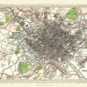
Old Map of Birmingham 1834 by John Dower and William Orr

![]()
Wall Art and Photo Gifts from MapSeeker
Old Map of Birmingham 1834 by John Dower and William Orr
A highly detailed reproduction city map of Birmingham originally published in London, 1834. Interestingly it shows the planned route of the Grand Junction Railway coming into the North of Birmingham, before the route was changed. Highly respected throughout England and Western Europe, William S. Orr was an early nineteenth century printseller and publisher, particularly of atlases and gazetteers. His maps of cities, counties and countries are noteworthy for their accuracy and very fine detailing. Indeed, few publishers from this period could compete with Orr for the large amount of information his maps contained. This original engraved map hails from Orrs 1834 Atlas, which contained not only all the regions of the world but plans of the primary cities as well. The engraving for the 1834 Atlas was entrusted mainly to the Pentonville artist, John Dower. Dower was well known for his maps and for his engravings of military scenes. So finely engraved is this map of Birmingham that one can only appreciate Dowers work with the aid of a magnifying lens. No finer example of early nineteenth century cartography exists than this engraved city map with its inset engraving of the Town Hall and reference key of major buildings. John Dower and William S. Orr were highly respected mapmakers, print sellers, and publishers of early 19th century London. Their work is known for is stunning accuracy and indeed, their work includes some of the most information rich maps of the period. In addition to his cartographic work, Dower is well known as an engraver of military scenes. Their primary work is the 1834 British Cyclopaedia
Welcome to the Mapseeker Image library and enter an historic gateway to one of the largest on-line collections of Historic Maps, Nostalgic Views, Vista's and Panorama's from a World gone by.
Media ID 20347146
Birmingham Birmingham City Birmingham City Map Birmingham Map Birmingham Town Plan City Of Birmingham Map Historic Birmingham Map Historic Map Map Of Birmingham Old Map Of Birmingham Old Town Plan Town Plan Of Birmingham John Dower
FEATURES IN THESE COLLECTIONS
> Arts
> Artists
> O
> John William Orr
> Arts
> Artists
> S
> John Seller
> Arts
> Photorealistic artworks
> Detailed art pieces
> Masterful detailing in art
> Europe
> United Kingdom
> England
> Birmingham
> Related Images
> Europe
> United Kingdom
> England
> London
> Art
> Venues
> London County Hall
> Europe
> United Kingdom
> England
> London
> Politics
> John Major
> Europe
> United Kingdom
> England
> London
> Towns
> Pentonville
> Europe
> United Kingdom
> England
> London
> Towns
> Somers Town
> Europe
> United Kingdom
> England
> London
> Towns
> Welling
> Europe
> United Kingdom
> England
> London
> Transport
> Railway
> MapSeeker
> British Town And City Plans
> English & Welsh PORTFOLIO
EDITORS COMMENTS
This highly detailed reproduction city map of Birmingham, originally published in London in 1834, offers a fascinating glimpse into the past. Created by renowned mapmakers John Dower and William Orr, this print showcases their exceptional skill and accuracy. What sets this map apart is its depiction of the planned route of the Grand Junction Railway entering the North of Birmingham before it was altered. This unique feature provides insight into the city's evolving infrastructure during that time period. William S. Orr was widely respected throughout England and Western Europe for his atlases and gazetteers. His maps were known for their meticulous detailing and wealth of information, making them highly sought after by collectors. The engraving itself is a masterpiece, showcasing Dower's talent as both a cartographer and an artist specializing in military scenes. The level of precision achieved on this map is truly remarkable; one can only fully appreciate Dower's work with the aid of a magnifying lens. Accompanying the main map is an inset engraving highlighting Birmingham's iconic Town Hall, along with a reference key to major buildings in the area. This comprehensive approach further demonstrates Dower and Orr's commitment to providing accurate representations of cities within their atlas. Overall, this engraved city map from 1834 stands as an exceptional example of early nineteenth-century cartography. Its historical significance combined with its stunning detail make it a valuable piece for any collector or enthusiast interested in exploring Birmingham's past.
MADE IN THE UK
Safe Shipping with 30 Day Money Back Guarantee
FREE PERSONALISATION*
We are proud to offer a range of customisation features including Personalised Captions, Color Filters and Picture Zoom Tools
SECURE PAYMENTS
We happily accept a wide range of payment options so you can pay for the things you need in the way that is most convenient for you
* Options may vary by product and licensing agreement. Zoomed Pictures can be adjusted in the Basket.