Home > Maps and Charts > World
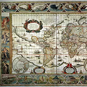
Map of the world 1800

![]()
Wall Art and Photo Gifts from Fine Art Storehouse
Map of the world 1800
Unleash your creativity and transform your space into a visual masterpiece!
THEPALMER
Media ID 15241435
© Roberto A Sanchez
Atlas Earth Map03 Oceania Paper Retro Revival World Map
FEATURES IN THESE COLLECTIONS
> Fine Art Storehouse
> The Magical World of Illustration
> Palmer Illustrated Collection
> Fine Art Storehouse
> Map
> Historical Maps
> Maps and Charts
> Early Maps
> Maps and Charts
> World
EDITORS COMMENTS
In this print titled "Map of the World 1800" we are transported back in time to an era when cartography was a meticulous art form. The image showcases a beautifully preserved antique world map, exuding a sense of nostalgia and wonder. The attention to detail is striking as every contour and boundary is meticulously outlined on the aged paper. This retro revival piece takes us on a journey across continents, unveiling the physical geography that shaped our planet centuries ago. From the vast oceans to the sprawling landmasses, each element tells its own story. As we explore this vintage atlas, our eyes are drawn to Oceania, with its scattered islands dotting the Pacific Ocean like precious gems. The intricate depiction of Earth's seas invites us to imagine brave explorers sailing uncharted waters in search of new lands and adventures. "The Map of the World 1800" by THEPALMER captures not only historical accuracy but also evokes emotions associated with discovery and curiosity about our planet's past. It serves as a reminder that even in today's digital age, there is still something enchanting about holding an old-fashioned map in your hands. This stunning artwork from Fine Art Storehouse transports us back in time while reminding us of humanity's enduring fascination with maps and their ability to connect us all through space and time.
MADE IN THE UK
Safe Shipping with 30 Day Money Back Guarantee
FREE PERSONALISATION*
We are proud to offer a range of customisation features including Personalised Captions, Color Filters and Picture Zoom Tools
SECURE PAYMENTS
We happily accept a wide range of payment options so you can pay for the things you need in the way that is most convenient for you
* Options may vary by product and licensing agreement. Zoomed Pictures can be adjusted in the Basket.