
Serbia Collection
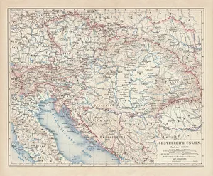
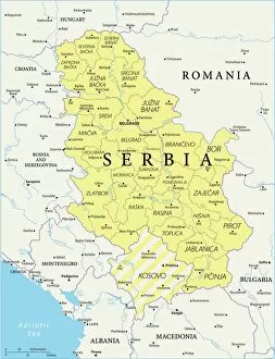
Serbia is a landlocked country located in southeastern Europe, bordered by Hungary to the north, Romania and Bulgaria to the east
Choose a picture from our Serbia Collection for your Wall Art and Photo Gifts
173 items


All Professionally Made to Order for Quick Shipping
-
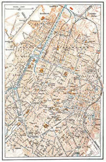
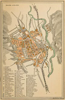
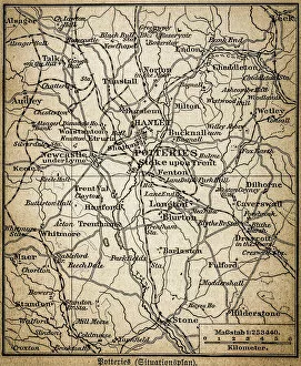
Serbia Collection
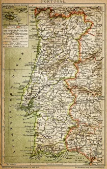
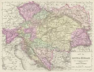
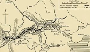
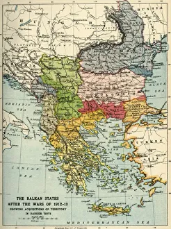
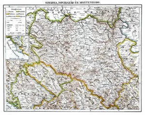
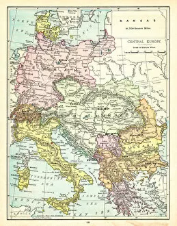
Serbia is a landlocked country located in southeastern Europe, bordered by Hungary to the north, Romania and Bulgaria to the east, North Macedonia to the south, Kosovo and Montenegro to the southwest. The capital city is Belgrade. The country has a population of approximately 7 million people and covers an area of 88,361 square kilometers. Serbia's economy relies heavily on agriculture and manufacturing industries such as automotive production. The official language spoken is Serbian while its currency is Serbian dinar (RSD). Tourist attractions include historic landmarks like Kalemegdan Fortress and Stari Grad district in Belgrade as well as natural wonders like Djavolja Varos rock formations.
+
Our beautiful pictures are available as Framed Prints, Photos, Wall Art and Photo Gifts
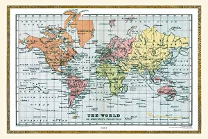
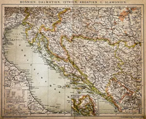
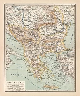
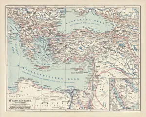
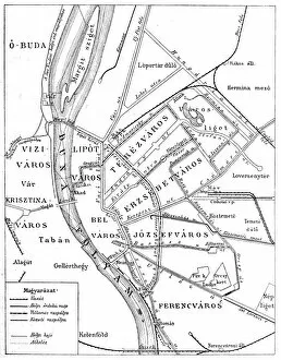
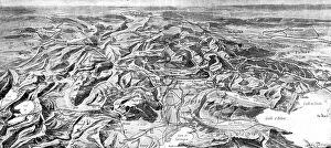
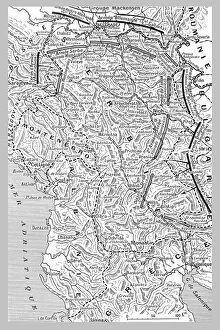
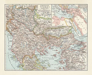
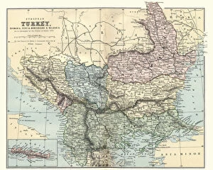
The Serbia collection from Media Storehouse is a stunning assortment of wall art and framed prints that showcase the beauty and history of Serbia. Our collection features an array of maps, charts, and illustrations that depict the country's geography, landmarks, culture, and traditions. Each piece in our collection is carefully crafted to capture the essence of Serbia's rich heritage. From vintage maps depicting ancient cities to modern-day aerial views showcasing its bustling metropolises, our collection offers something for everyone. Whether you're looking for a unique addition to your home decor or a thoughtful gift for someone special, these prints are sure to impress. With high-quality printing techniques used on premium paper stock, each print in our collection is designed to last for years without fading or losing its vibrancy. So why not bring a touch of Serbian charm into your home with one of these beautiful pieces?
+
What are Serbia (Maps and Charts) art prints?
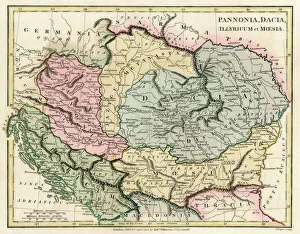
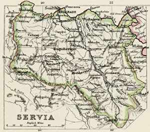
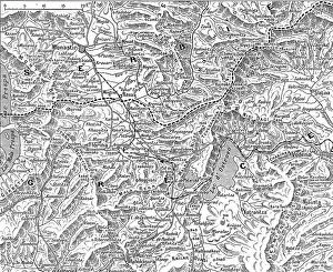
Serbia art prints are high-quality reproductions of vintage maps and charts depicting the geography, topography, and historical landmarks of Serbia. These art prints showcase the intricate details of old cartographic techniques that were used to create these maps centuries ago. They feature a range of styles from hand-drawn illustrations to colorful lithographs, providing a unique insight into the country's past. These art prints are perfect for history buffs, collectors, or anyone who appreciates beautiful artwork. They can be displayed in homes or offices as decorative pieces or used as educational tools for students studying geography or history. We offer a wide selection of Serbia art prints in various sizes and formats such as canvas prints, framed prints, and poster prints. Each print is carefully produced using archival-grade materials to ensure long-lasting quality. With their rich colors and intricate details, these art prints make excellent gifts for anyone interested in Serbian culture or history.
+
What Serbia (Maps and Charts) art prints can I buy from Media Storehouse?
We offer a wide range of Serbia Maps and Charts art prints that are perfect for those who love to explore the world through visual representations. These art prints showcase various maps and charts of Serbia, including historical maps, topographical maps, political maps, and more. You can choose from different sizes and formats such as canvas prints or framed prints to suit your preferences. The high-quality printing technology used by Media Storehouse ensures that every detail is captured in these beautiful art pieces. Whether you're looking for a unique addition to your home decor or an educational tool for your classroom, there's something for everyone in this collection. With so many options available at Media Storehouse, you'll surely find the perfect Serbia Maps and Charts art print that suits your style and taste.
+
How do I buy Serbia (Maps and Charts) art prints?
To buy Serbia art prints from Media Storehouse, you can browse our extensive collection of high-quality images online. Once you have found the print that you want to purchase, simply add it to your cart and proceed to checkout. During the checkout process, you will be prompted to enter your shipping information and payment details. We offer a variety of printing options for their art prints, including canvas prints, framed prints, and poster prints. You can choose the size and format that best suits your needs. Our website is easy to navigate with a search bar at the top where you can type in 'Serbia Maps' or 'Serbia Charts' which will bring up all relevant results. We also offer customer support if needed through email or phone. Buying Serbia art prints from Media Storehouse is a straightforward process that allows you to easily find and purchase beautiful artwork for your home or office.
+
How much do Serbia (Maps and Charts) art prints cost?
We offer a wide range of Serbia art prints at varying prices. Our collection includes high-quality prints featuring detailed maps and charts that showcase the beauty and history of Serbia. The cost of our art prints depends on various factors such as size, framing options, and quality. We strive to provide affordable yet premium quality art prints to our customers. Our team sources the best materials for printing to ensure that each piece is vibrant, sharp, and long-lasting. We also offer different sizes to cater to different preferences and budgets. Whether you're looking for a small print or a large one with intricate details, we have something for everyone. Our Serbia art prints are perfect for adding character to your home or office space while showcasing your love for this beautiful country's culture and heritage.
+
How will my Serbia (Maps and Charts) art prints be delivered to me?
We take great care in ensuring that your Serbia art prints are delivered to you safely and securely. We use high-quality packaging materials to protect your print during transit, including sturdy cardboard tubes for rolled prints and flat-pack boxes for mounted prints. Once your order has been processed, our team will carefully package your print and arrange for it to be shipped directly to you. Depending on the size of your print and your location, we may use a range of shipping methods such as standard postal services or courier delivery. When you receive your Serbia art print from us, it will be ready for framing or display straight away. We pride ourselves on delivering high-quality products that meet the needs of our customers, so if you have any questions about delivery or anything else related to our service please don't hesitate to get in touch with us.