Home > Europe > United Kingdom > England > Cheshire > Aldford
Cheshire East SK9 1 Map

![]()
Wall Art and Photo Gifts from Map Marketing
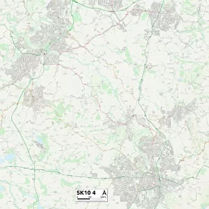
Cheshire East SK9 1 Map
Postcode Sector Map of Cheshire East SK9 1
Media ID 19977570
Alderley Road Ashcroft Ashford Road Berry Close Broadway Brook Lane Burnside Close Cheshire East Church Street Donkey Lane Fairfax Drive Green Lane Greenway Grosvenor Close Grove Way Heathfield Mill Road Mill Street Parkway Silverdale Drive South Drive Station Road Stockton Road Swan Street Westgate Westminster Drive Whitehall Close Wilmslow Road Wilmslow
FEATURES IN THESE COLLECTIONS
> Animals
> Farm
> Donkeys
> Related Images
> Arts
> Portraits
> Pop art gallery
> Street art portraits
> Europe
> France
> Canton
> Landes
> Europe
> United Kingdom
> England
> Cheshire
> Aldford
> Europe
> United Kingdom
> England
> Cheshire
> Croft
> Europe
> United Kingdom
> England
> Cheshire
> Related Images
> Europe
> United Kingdom
> England
> Cheshire
> Wilmslow
> Europe
> United Kingdom
> Scotland
> Scottish Borders
> Melrose
> Map Marketing
> Postcode Sector Maps
> SK - Stockport
> Maps and Charts
> Related Images
MADE IN THE UK
Safe Shipping with 30 Day Money Back Guarantee
FREE PERSONALISATION*
We are proud to offer a range of customisation features including Personalised Captions, Color Filters and Picture Zoom Tools
SECURE PAYMENTS
We happily accept a wide range of payment options so you can pay for the things you need in the way that is most convenient for you
* Options may vary by product and licensing agreement. Zoomed Pictures can be adjusted in the Basket.