Home > Europe > United Kingdom > Wales > Pembrokeshire > Narberth
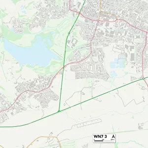
Pembrokeshire SA69 9 Map

![]()
Wall Art and Photo Gifts from Map Marketing
Pembrokeshire SA69 9 Map
Postcode Sector Map of Pembrokeshire SA69 9
Media ID 19979797
Broadfield Brookdale Cambrian Place Castle View Church Terrace Cross Park Ferndale Frances Road Gorse Hill Green Park Hawthorn Close High Street Highgrove Lawnswood Milford Street Moreton Moreton Close Moreton Lane North Close Oak Grove Pembrokeshire Ridgeway Close Sandy Hill Road The Glen The Ridgeway The Strand The Valley Valley Close Valley Grove Valley Road Westfield Court Westfield Road Sardis Saundersfoot
FEATURES IN THESE COLLECTIONS
> Animals
> Fishes
> S
> Swallower
> Arts
> Artists
> G
> Charles Green
> Arts
> Artists
> O
> Oceanic Oceanic
> Arts
> Portraits
> Pop art gallery
> Street art portraits
> Europe
> United Kingdom
> Wales
> Pembrokeshire
> Narberth
> Europe
> United Kingdom
> Wales
> Pembrokeshire
> Related Images
> Map Marketing
> Postcode Sector Maps
> SA - Swansea
> Maps and Charts
> Related Images
MADE IN THE UK
Safe Shipping with 30 Day Money Back Guarantee
FREE PERSONALISATION*
We are proud to offer a range of customisation features including Personalised Captions, Color Filters and Picture Zoom Tools
SECURE PAYMENTS
We happily accept a wide range of payment options so you can pay for the things you need in the way that is most convenient for you
* Options may vary by product and licensing agreement. Zoomed Pictures can be adjusted in the Basket.