Home > Africa > Egypt > Maps
Rhondda Cynon Taf CF37 1 Map

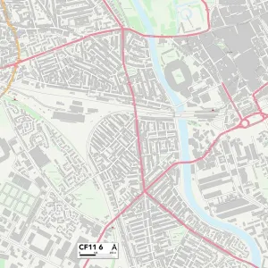
![]()
Wall Art and Photo Gifts from Map Marketing
Rhondda Cynon Taf CF37 1 Map
Postcode Sector Map of Rhondda Cynon Taf CF37 1
Media ID 19967210
Albert Road Alexandra Road Arran Close Balmoral Close Barry Road Belle Vue Terrace Bertha Street Bethel Street Birchwood Avenue Black Road Bridge Street Broadway Brook Street Bryn Eglwys Burns Way Cambrian Place Castle Street Charles Street Cliff Terrace Duke Street Factory Lane Ford Road Forest Grove Forest Road Graig Terrace High Street Hilda Street James Place John Street King Street Kingswood Laundry Road Laura Street Lee Street Lewis Street Llantrisant Road Meadow Street Nile Street Oxford Street Park Close Park Street Penylan Road Phillip Street Princess Street Quarry Road Queen Street Rhondda Cynon Taf River Street Ross Close Rowan Close St Andrews Close St Michaels Avenue Tower Street Union Street Vaughan Street Walters Road Wood Road Woodland Terrace Pontypridd
FEATURES IN THESE COLLECTIONS
> Africa
> Egypt
> Related Images
> Animals
> Mammals
> Muridae
> House Mouse
> Architecture
> Towers
> Castles
> Architecture
> Towers
> Tower Bridge
> Arts
> Artists
> B
> Charles Barry
> Arts
> Artists
> B
> Charles Brooking
> Arts
> Artists
> B
> James Barry
> Arts
> Artists
> B
> John Brooks
> Arts
> Artists
> C
> Charles Collins
> Map Marketing
> Postcode Sector Maps
> CF - Cardiff
> Map Marketing
> UK Maps
MADE IN THE UK
Safe Shipping with 30 Day Money Back Guarantee
FREE PERSONALISATION*
We are proud to offer a range of customisation features including Personalised Captions, Color Filters and Picture Zoom Tools
SECURE PAYMENTS
We happily accept a wide range of payment options so you can pay for the things you need in the way that is most convenient for you
* Options may vary by product and licensing agreement. Zoomed Pictures can be adjusted in the Basket.