Home > Europe > United Kingdom > Scotland > Strathclyde > Kilbarchan
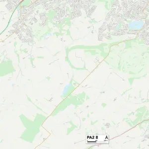
Renfrewshire PA11 3 Map

![]()
Wall Art and Photo Gifts from Map Marketing
Renfrewshire PA11 3 Map
Postcode Sector Map of Renfrewshire PA11 3
Media ID 19977993
Back Road Beech Avenue Broom Place Castle Road Church Road Cypress Grove Elm Road Golf Course Road Hazelwood Avenue Hazelwood Lane Hazelwood Road Hillview Road Hope Avenue Houston Road Juniper Avenue Laurel Way Loch Road Lomond Crescent Main Street Maxwell Place Moss Road Park Road Renfrewshire School Wynd St Andrews Drive Sunningdale Drive The Grove Turnberry Drive Woodside Avenue
FEATURES IN THESE COLLECTIONS
> Arts
> Portraits
> Pop art gallery
> Street art portraits
> Europe
> United Kingdom
> Scotland
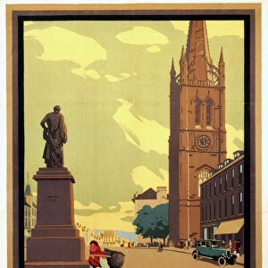
> Angus
> Montrose
> Europe
> United Kingdom
> Scotland
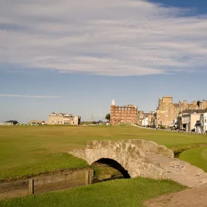
> Fife
> St Andrews
> Europe
> United Kingdom
> Scotland
> Renfrewshire
> Europe
> United Kingdom
> Scotland
> Scottish Borders
> Kelso
> Europe
> United Kingdom
> Scotland
> Strathclyde
> Kilbarchan
> Europe
> United Kingdom
> Scotland
> Strathclyde
> Troon
> Map Marketing
> Postcode Sector Maps
> PA - Paisley
> Maps and Charts
> Related Images
MADE IN THE UK
Safe Shipping with 30 Day Money Back Guarantee
FREE PERSONALISATION*
We are proud to offer a range of customisation features including Personalised Captions, Color Filters and Picture Zoom Tools
SECURE PAYMENTS
We happily accept a wide range of payment options so you can pay for the things you need in the way that is most convenient for you
* Options may vary by product and licensing agreement. Zoomed Pictures can be adjusted in the Basket.