Home > Europe > United Kingdom > England > London > Towns > Oakwood
Reigate and Banstead RH1 3 Map

![]()
Wall Art and Photo Gifts from Map Marketing
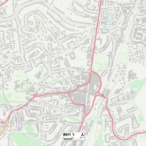
Reigate and Banstead RH1 3 Map
Postcode Sector Map of Reigate and Banstead RH1 3
Media ID 19979095
Albert Road Albury Road Ash Close Ashcombe Road Beech Road Bourne Road Bramblewood Brook Road Chesterton Drive Church Hill Dean Lane Deans Road Devon Road Endsleigh Road Glebe Road Grange Close Grange Drive Hanover Close High Street Manor Road Mansfield Drive Melton Road Mill Lane Nutfield Road Oakwood Road Old Mill Lane Portland Drive Purbeck Close Regent Close Reigate And Banstead Rocky Lane Rookwood Close Sandstone Close School Hill Shepherds Hill Southcote Road Station Road Station Road North Sutton Gardens The Crossways Wood Street Woodlands Close Quality Street
FEATURES IN THESE COLLECTIONS
> Arts
> Artists
> B
> Warwick Brookes
> Arts
> Portraits
> Pop art gallery
> Street art portraits
> Europe
> United Kingdom
> England
> Devon
> Ash
> Europe
> United Kingdom
> England
> Devon
> Church Green
> Europe
> United Kingdom
> England
> Devon
> Dean
> Europe
> United Kingdom
> England
> Devon
> Related Images
> Europe
> United Kingdom
> England
> Devon
> Woodland
> Europe
> United Kingdom
> England
> London
> Boroughs
> Sutton
> Europe
> United Kingdom
> England
> London
> Towns
> Mill Hill
> Europe
> United Kingdom
> England
> London
> Towns
> Oakwood
> Map Marketing
> Postcode Sector Maps
> RH - Redhill
MADE IN THE UK
Safe Shipping with 30 Day Money Back Guarantee
FREE PERSONALISATION*
We are proud to offer a range of customisation features including Personalised Captions, Color Filters and Picture Zoom Tools
SECURE PAYMENTS
We happily accept a wide range of payment options so you can pay for the things you need in the way that is most convenient for you
* Options may vary by product and licensing agreement. Zoomed Pictures can be adjusted in the Basket.